The mega-transect approach as a basis for development Siberian Environmental Change Network (SecNet) презентация
- The mega-transect approach as a basis for development Siberian Environmental Change Network (SecNet)

Содержание
- 2. Siberia is not just a land, it is the Universe Located on the vast territories from
- 3. A special type of human beings Unique geography Unique natural conditions Unique historical project, the history
- 4. TSSW Mission To engage Siberia in the World. To engage the World in the development of
- 5. Earth and natural sciences Arctic system Climate change and water recourses Biodiversity Medicine and man «Siberian
- 6. The main activity of TSW focused on creating — scientific — educational — intellectual (analytical) —
- 7. Examples of products ● Four-dimensional mapping of Siberia in all subjects of the Centre ● Analysis,
- 8. Formation of integrated interdisciplinary educational programs Science Economics Society transfer of knowledge and technology Master programs
- 9. Affiliate networks Research nets and collaborations
- 10. Mega-science and mega-facilities Large Hadron Collider (LHC) in Switzerland The concept of "mega-science" is usually applied
- 11. unique wetland area; the world's largest mire Great Vasyugan (area of 7.5 million hectares); 40% pristine
- 12. Western Siberia as a natural mega-facility
- 13. New Mega-facility in Western Siberia developed by Tomsk State University, a member of INTERACT Unique mega-transect
- 14. Siberian Mega-transect Conceptual pathway Identifying landscape units Identifying past changes, characterising baseline conditions, projecting future changes
- 15. INTERACT is an infrastructure project, a circumarctic network of currently 76 terrestrial field bases in northern
- 17. Siberian Environmental Change Network (SecNet) Siberian Environmental Change Network (SecNET) established in 2016 is an open
- 18. We have brought experts together from throughout Russia and abroad who study many different fields. Many
- 19. Link world-class international and Russian institutes researching Siberia Link multiple disciplines and approaches Provide a “one-stop-shop”
- 20. SecNET Siberian Mega-transect (work in progress) Desert Mountain Taiga Tundra Steppes variation in space from the
- 21. Approaches to characterise environmental change in the units identified Baseline establishment Remote sensing Surveys, Herbarium, Ecology,
- 22. Approaches to identify drivers of change Biotic e.g. herbivory, succession, species migration Anthropogenic e.g. land use,
- 23. Launch the Siberian Environmental Change Network (SecNET) at the workshop in October 2. Transpolar super mega-transect
- 24. Join SecNet If you wish to join the Network as a Partner, SecNet management encourages you
- 25. Vast areas of palsa bogs with great number of lakes on watershed surface in northern taiga
- 26. The process of permafrost thaw (thermokarst) on the edge of plateaux palsa at the North of
- 27. Lakes, ponds and drained thaw lake basins Lakes, ponds and drained thaw lake basins (khasyreis) are
- 28. Endogenous cyclic development of palsas Scandinavian scientists have made detailed long-term observations of palsas and have
- 29. The first stage of permafrost thaw (thermokarst) on the palsa bog surface (photographer S. Kirpotin) Cracks
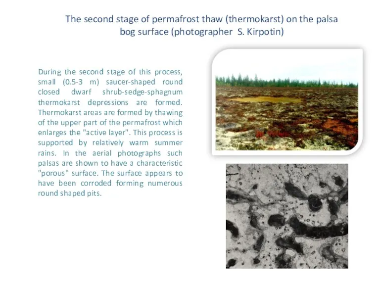
- 30. The second stage of permafrost thaw (thermokarst) on the palsa bog surface (photographer S. Kirpotin) During
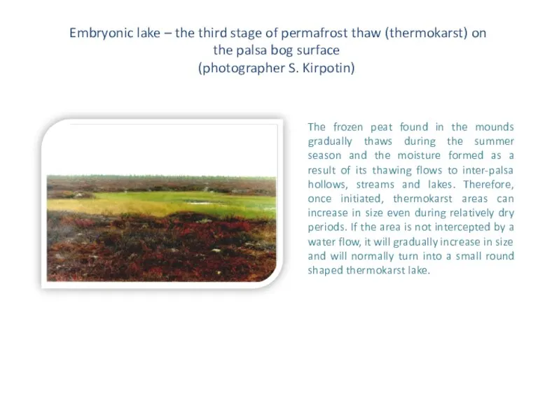
- 31. Embryonic lake – the third stage of permafrost thaw (thermokarst) on the palsa bog surface (photographer
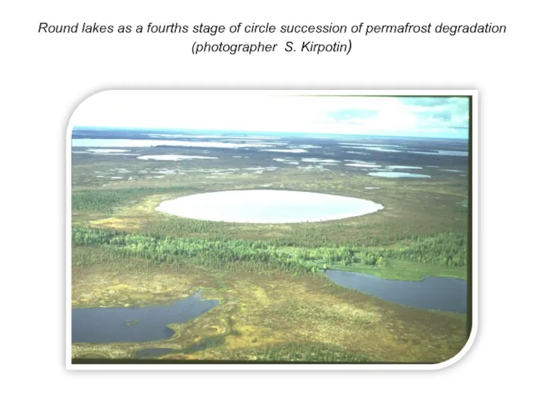
- 32. Round lakes as a fourths stage of circle succession of permafrost degradation (photographer S. Kirpotin)
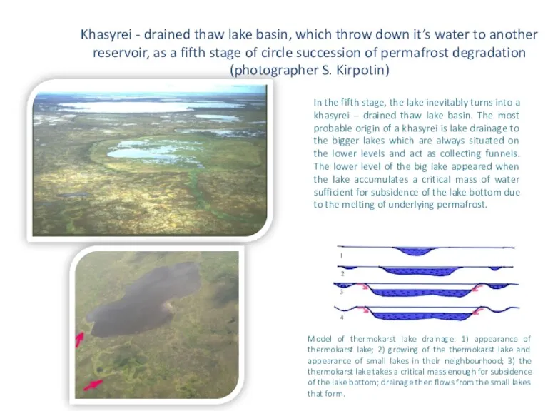
- 33. Khasyrei - drained thaw lake basin, which throw down it’s water to another reservoir, as a
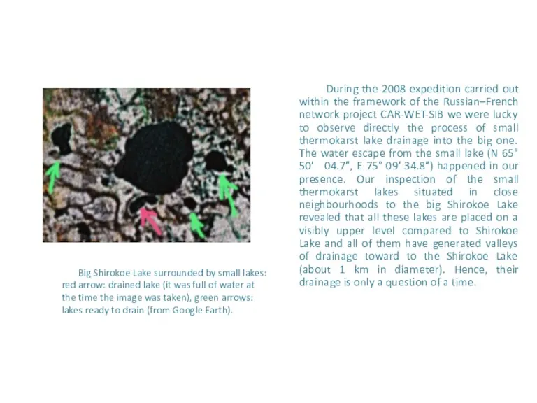
- 34. During the 2008 expedition carried out within the framework of the Russian–French network project CAR-WET-SIB we
- 35. As a rule, a big thermokarst lake (like Shirokoe Lake) is surrounded by a cluster of
- 36. Another way of lake drainage could be the lake evacuation to a river.
- 37. Stages of khasyrei development To sum up, we can suggest four stages of khasyrei development: freshly
- 38. Mature khasyrei with yang frozen peat mounds, as a last stage of circle succession of palsa’s
- 39. The khasyrei bottom usually is from one to four metres lower than the surrounding flat palsas.
- 40. The scheme of the circle palsa’s succession
- 41. Fresh thermokarst subsidence. You can see the dwarf shrubs go under water (photographer S. Kirpotin, 2004)
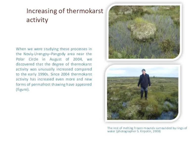
- 42. The rest of melting frozen mounds surrounded by rings of water (photographer S. Kirpotin, 2008) When
- 43. Edges of the big (1 km) lakes (photographer S. Kirpotin, 2004)
- 44. Edges of the big (1 km) lake Shirokoe (photographer S. Kirpotin, 2008)
- 45. Edge (shore-line) of the small thermokarst lake. You can see the dwarf shrubs which go under
- 46. Reindeer skeleton - “alive” witness of permafrost thawing 2004 2008 (the same place) photographer Sergey Kirpotin
- 47. Thermokarst processes increase methane emission, especially from yedomas (ice-rich Pleistocene soils with a high labile carbon
- 48. Small lakes The small lakes are especially important in the context of continuing environmental changes and
- 49. Western Siberia thaw lakes as mediators of CO2 flux from soil to the atmosphere Recently, it
- 50. Fragment of space images Landsat-7 (07.08.1999г.), central part of PT-5 Simbols: 1 – thermokarst lakes; 2
- 51. Space image Landsat-1 (10.08.1973) with indicated thermokarst lakes
- 52. Fragment of space image Spot-5 ( 20.07.2005)
- 53. Comparison of space images Landsat-1 (10.08.1973) and Spot-5 ( 20.07.2005)
- 54. Consequent stages of decrease of lake 9 area Changes of area of thermokarst lake 9
- 55. Consequent stages of decrease of lake 7 area Thermokarst lake 7 areas (red) changes
- 56. S= 5625,0 S= 552,0 LANDSAT -1 (1973) ALOS (2006) Thermokarst lakes Озеро Сихтынэмтор сократилось на 90%
- 57. Location of pilot territories in West-Siberian permafrost
- 58. Landsat - 1 (scanner MSS), 10.08.1973 Landsat - 5 (scanner MSS), 27.07.1984 Landsat - 5 (scanner
- 59. Through increasing thermokarst activity, two contrasting processes are observed in the West-Siberian cryolithozone: i) the increase
- 60. International projects Currently our Centre participate in the EU JPI-Climate Project: Climate impact on the carbon
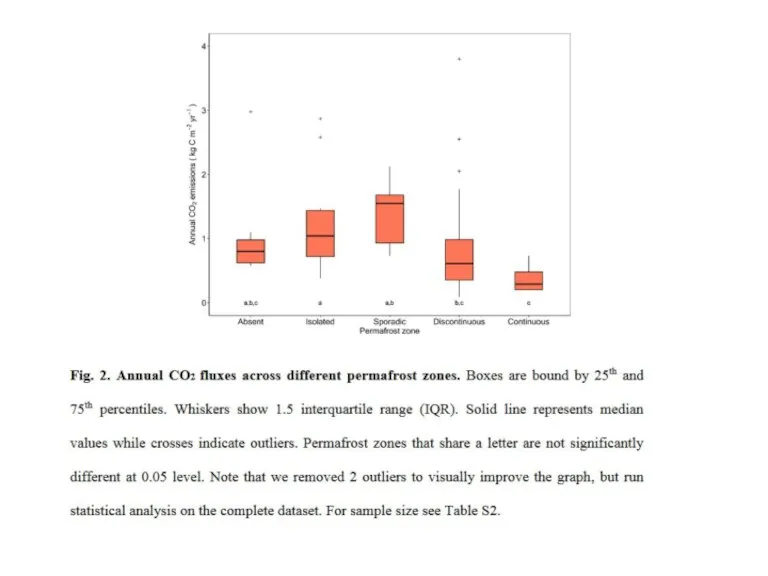
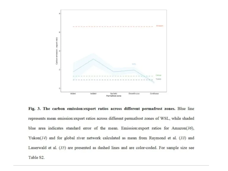
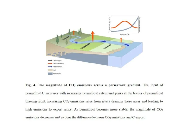
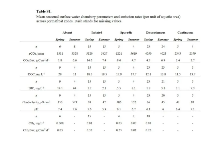
- 61. High riverine CO2 emissions at the permafrost boundary of Western Siberia Authors: S. Serikova, O. Pokrovsky,
- 66. Climate change and social consequences, impact on infrastructure The destructive impact of permafrost thaw affects not
- 67. Yamal anthrax outbreak could just be the beginning Animal burials located on the permafrost also present
- 68. Prompt warming of a climate in Western Siberia already today has appreciable economic consequences Masts that
- 70. Скачать презентацию
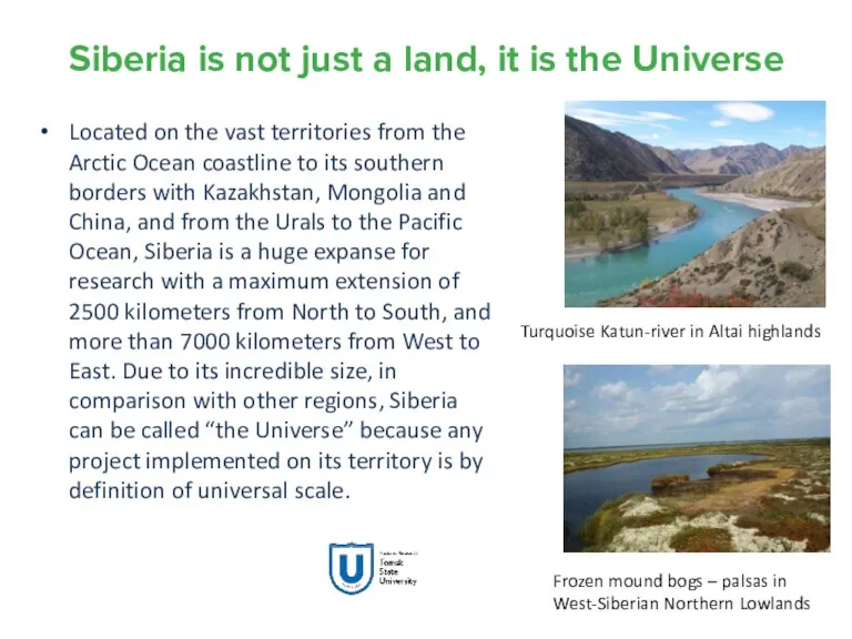
Siberia is not just a land, it is the Universe
Located on
Siberia is not just a land, it is the Universe
Located on
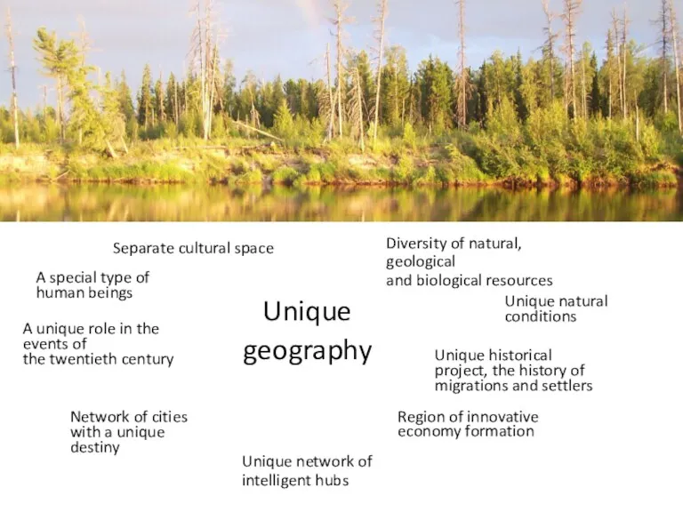
A special type of
human beings
Unique geography
Unique natural conditions
Unique historical project,
A special type of
human beings
Unique geography
Unique natural conditions
Unique historical project,
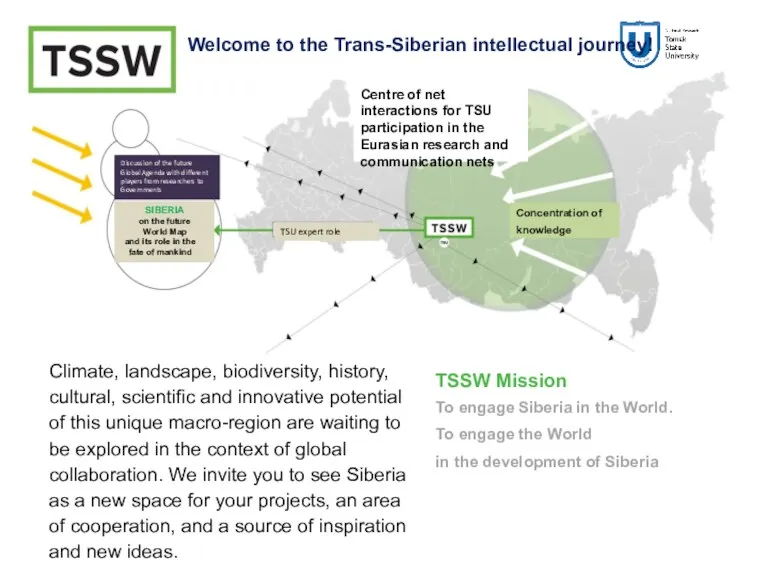
TSSW Mission
To engage Siberia in the World.
To engage the World
TSSW Mission
To engage Siberia in the World.
To engage the World
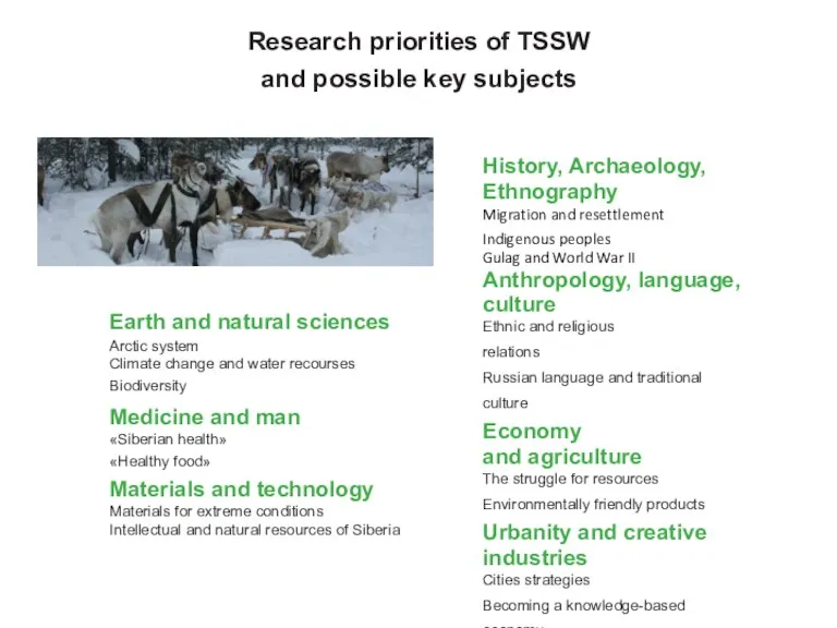
Earth and natural sciences
Arctic system
Climate change and water recourses
Biodiversity
Medicine and
Earth and natural sciences
Arctic system
Climate change and water recourses
Biodiversity
Medicine and
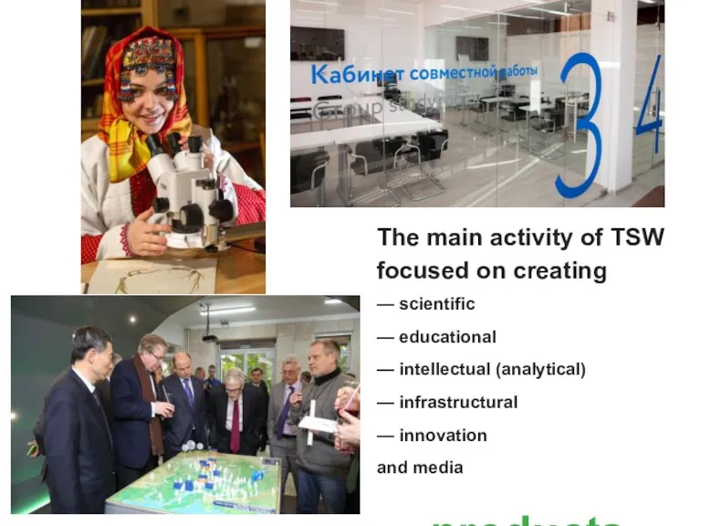
The main activity of TSW focused on creating
— scientific
— educational
—
The main activity of TSW focused on creating
— scientific
— educational
—
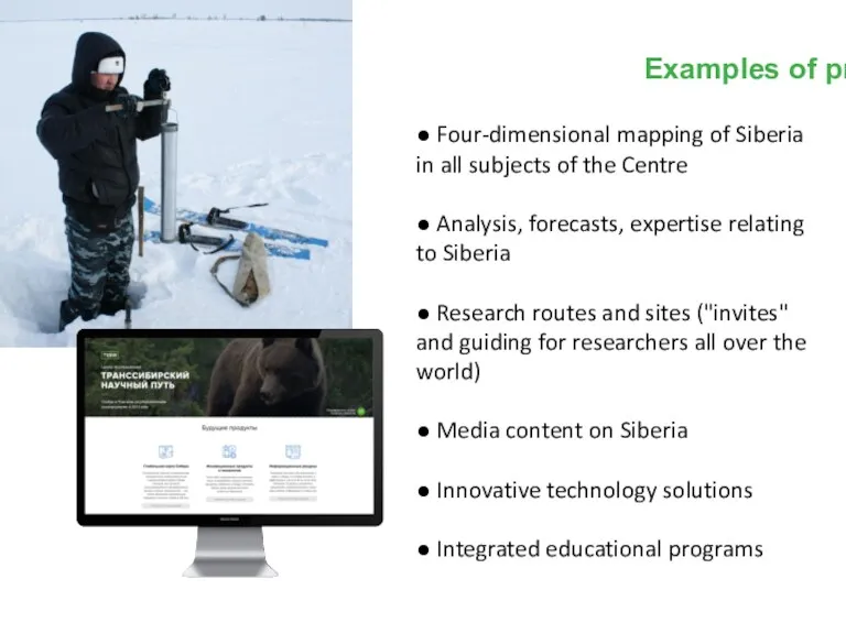
Examples of products
● Four-dimensional mapping of Siberia in all subjects of
Examples of products
● Four-dimensional mapping of Siberia in all subjects of
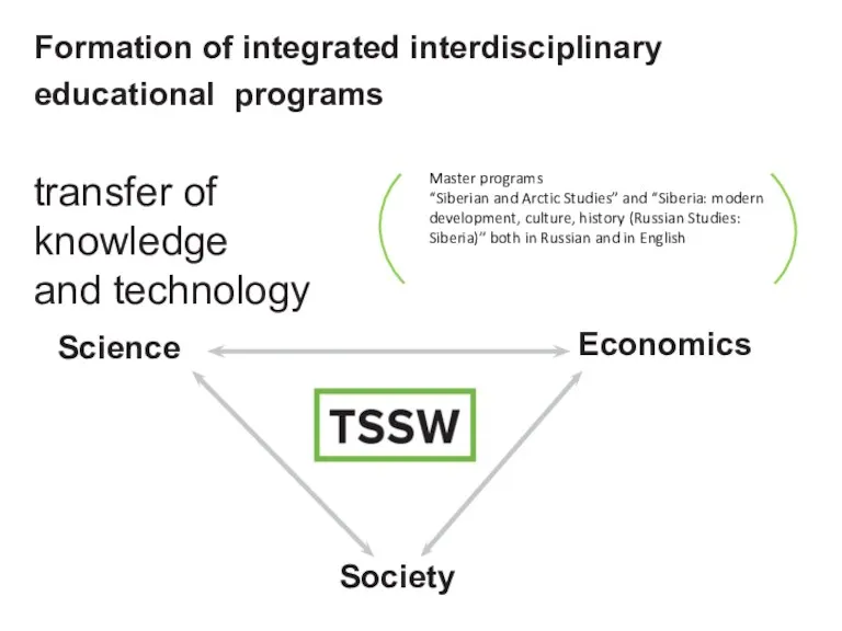
Formation of integrated interdisciplinary educational programs
Science
Economics
Society
transfer of
knowledge
and technology
Master programs
“Siberian
Formation of integrated interdisciplinary educational programs
Science
Economics
Society
transfer of
knowledge
and technology
Master programs
“Siberian
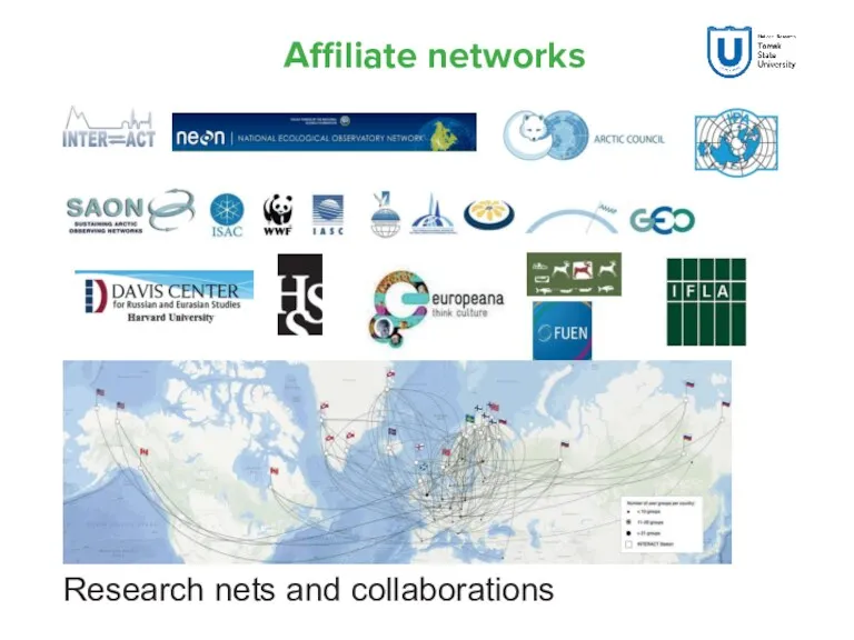
Affiliate networks
Research nets and collaborations
Affiliate networks
Research nets and collaborations
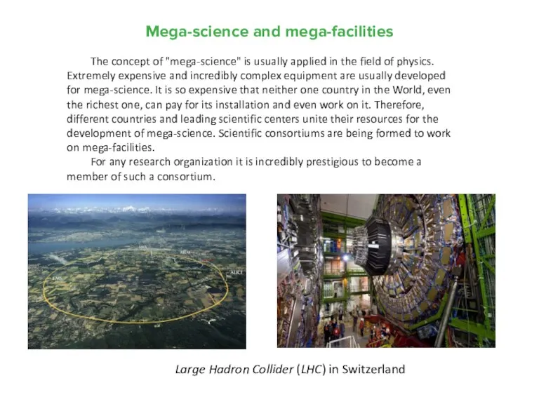
Mega-science and mega-facilities
Large Hadron Collider (LHC) in Switzerland
The concept
Mega-science and mega-facilities
Large Hadron Collider (LHC) in Switzerland
The concept
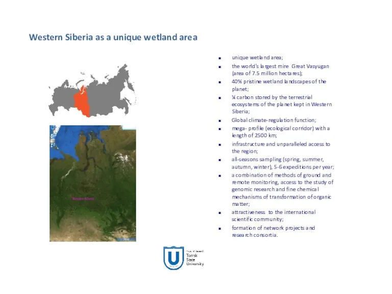
unique wetland area;
the world's largest mire Great Vasyugan (area of 7.5
unique wetland area;
the world's largest mire Great Vasyugan (area of 7.5
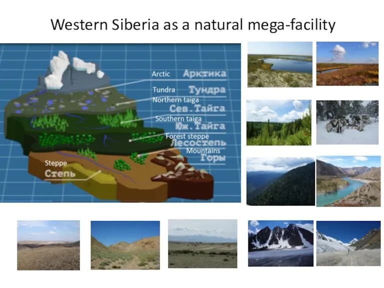
Western Siberia as a natural mega-facility
Western Siberia as a natural mega-facility
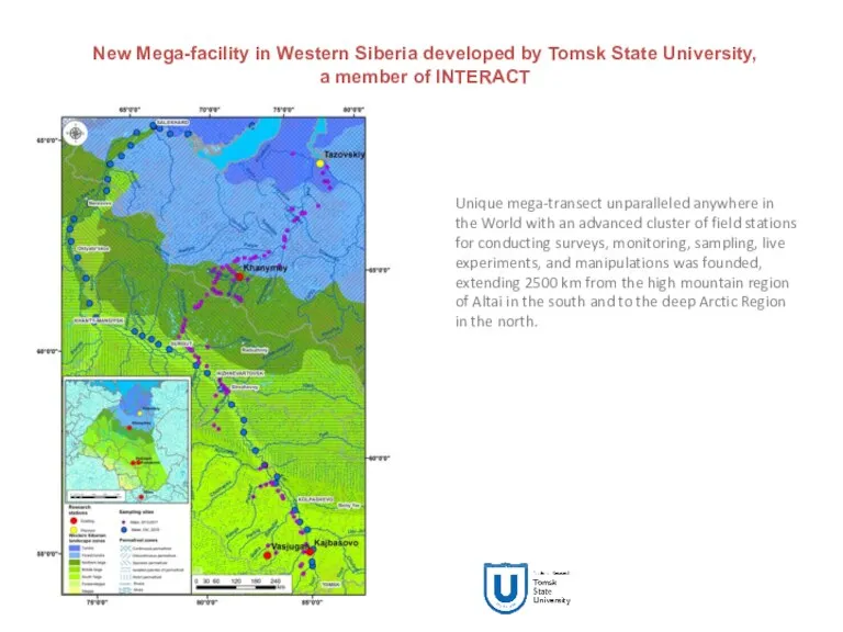
New Mega-facility in Western Siberia developed by Tomsk State University,
a
New Mega-facility in Western Siberia developed by Tomsk State University,
a
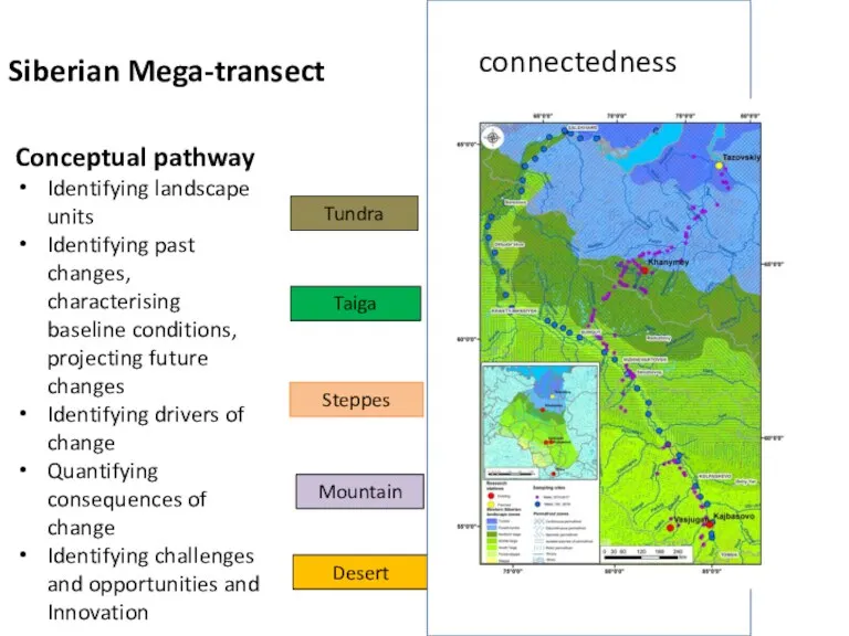
Siberian Mega-transect
Conceptual pathway
Identifying landscape units
Identifying past changes, characterising baseline conditions,
Conceptual pathway
Identifying landscape units
Identifying past changes, characterising baseline conditions,
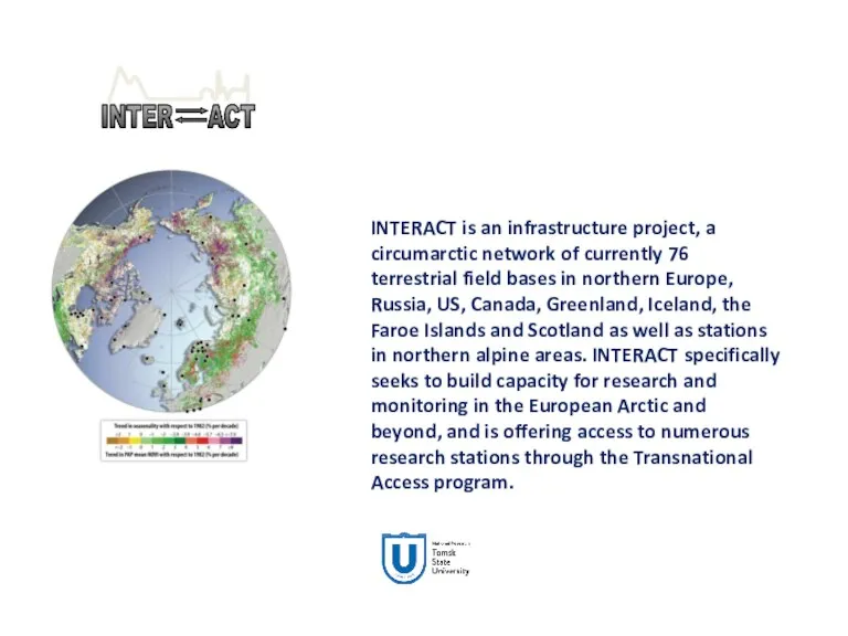
INTERACT is an infrastructure project, a circumarctic network of currently 76
INTERACT is an infrastructure project, a circumarctic network of currently 76
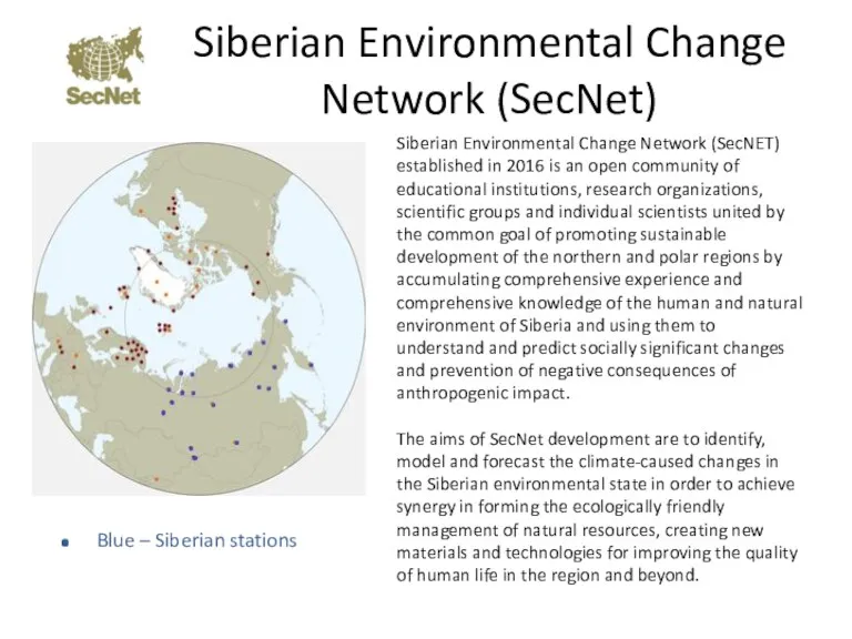
Siberian Environmental Change Network (SecNet)
Siberian Environmental Change Network (SecNET) established in
Siberian Environmental Change Network (SecNet)
Siberian Environmental Change Network (SecNET) established in
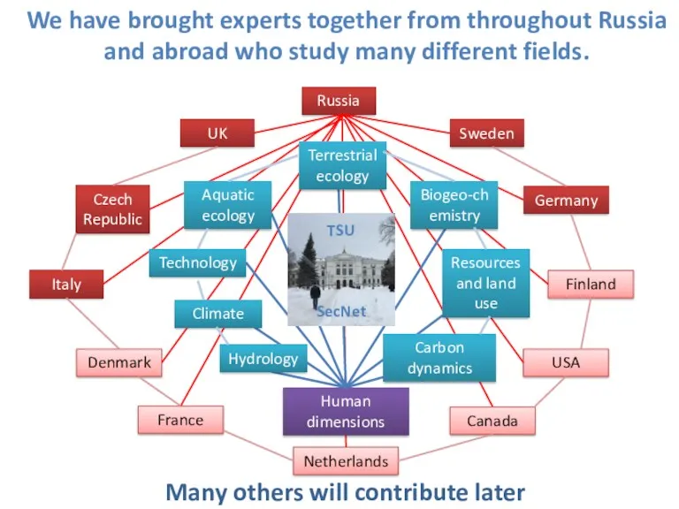
We have brought experts together from throughout Russia and abroad who
We have brought experts together from throughout Russia and abroad who
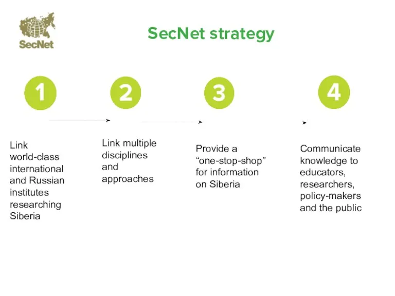
Link world-class international and Russian institutes researching Siberia
Link multiple disciplines
and
Link world-class international and Russian institutes researching Siberia
Link multiple disciplines and
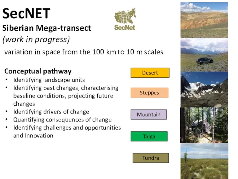
SecNET
Siberian Mega-transect
(work in progress)
Desert
Mountain
Taiga
Tundra
Steppes
variation in space from the 100
SecNET
Siberian Mega-transect
(work in progress)
Desert
Mountain
Taiga
Tundra
Steppes
variation in space from the 100
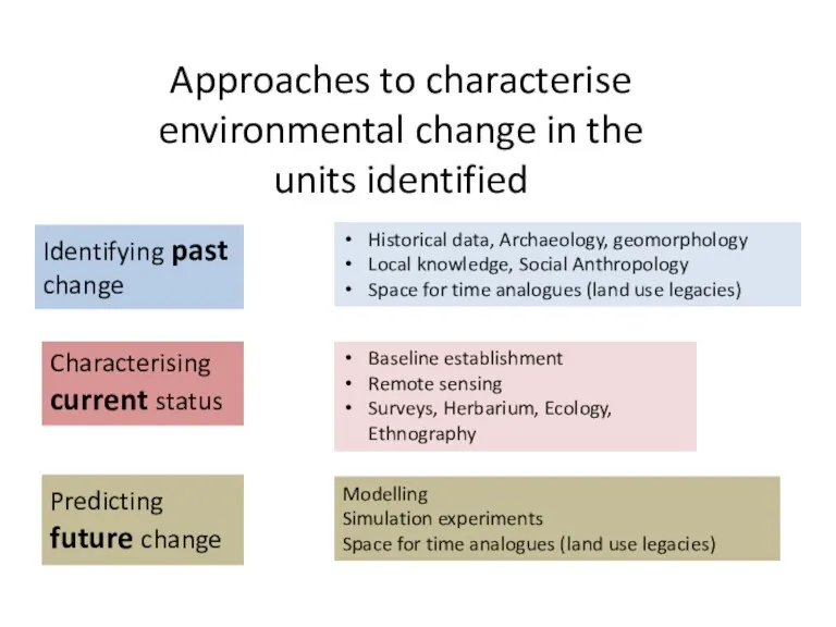
Approaches to characterise environmental change in the units identified
Baseline establishment
Remote sensing
Surveys,
Approaches to characterise environmental change in the units identified
Baseline establishment
Remote sensing
Surveys,
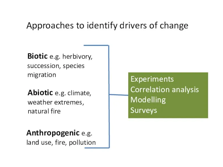
Approaches to identify drivers of change
Biotic e.g. herbivory, succession, species migration
Approaches to identify drivers of change
Biotic e.g. herbivory, succession, species migration
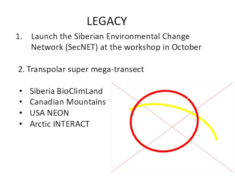
Launch the Siberian Environmental Change Network (SecNET) at the workshop in
Launch the Siberian Environmental Change Network (SecNET) at the workshop in
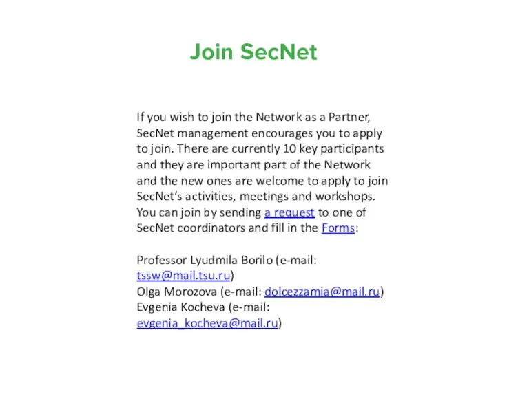
Join SecNet
If you wish to join the Network as a Partner,
Join SecNet
If you wish to join the Network as a Partner,
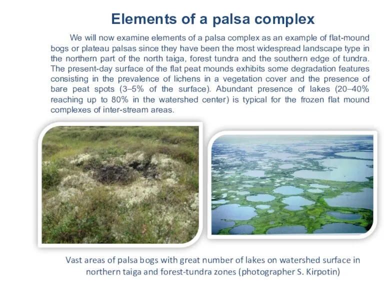
Vast areas of palsa bogs with great number of lakes on
Vast areas of palsa bogs with great number of lakes on
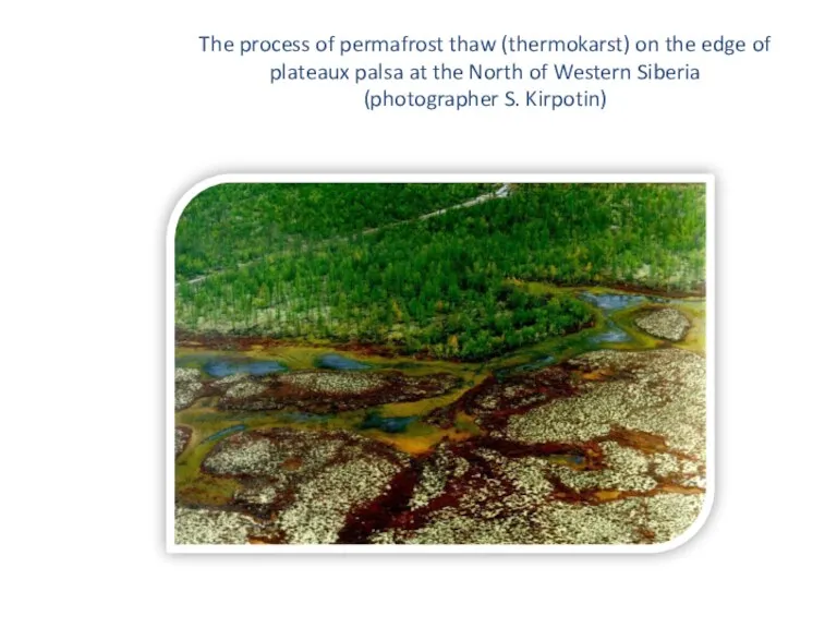
The process of permafrost thaw (thermokarst) on the edge of plateaux
The process of permafrost thaw (thermokarst) on the edge of plateaux
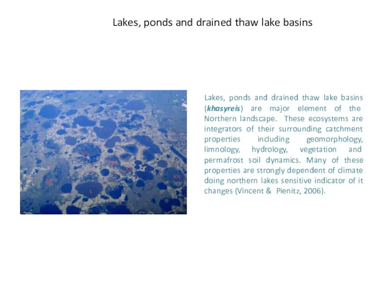
Lakes, ponds and drained thaw lake basins
Lakes, ponds and drained thaw
Lakes, ponds and drained thaw lake basins
Lakes, ponds and drained thaw
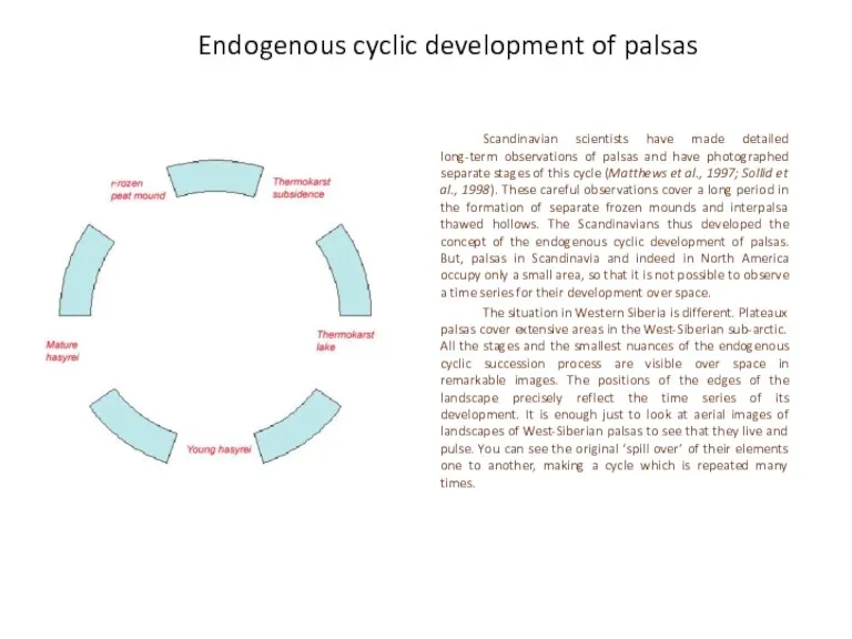
Endogenous cyclic development of palsas
Scandinavian scientists have made detailed long-term observations
Endogenous cyclic development of palsas
Scandinavian scientists have made detailed long-term observations
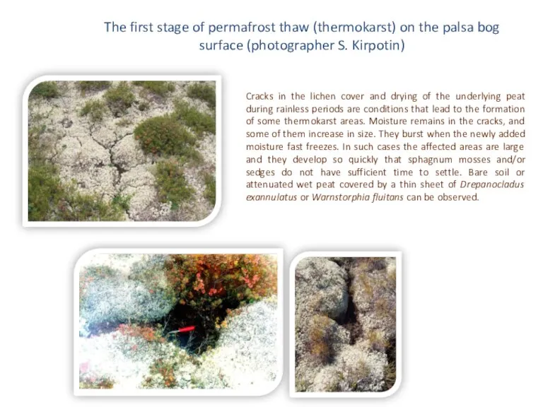
The first stage of permafrost thaw (thermokarst) on the palsa bog
The first stage of permafrost thaw (thermokarst) on the palsa bog
The second stage of permafrost thaw (thermokarst) on the palsa bog
The second stage of permafrost thaw (thermokarst) on the palsa bog
Embryonic lake – the third stage of permafrost thaw (thermokarst) on
Embryonic lake – the third stage of permafrost thaw (thermokarst) on
Round lakes as a fourths stage of circle succession of permafrost
Round lakes as a fourths stage of circle succession of permafrost
Khasyrei - drained thaw lake basin, which throw down it’s water
Khasyrei - drained thaw lake basin, which throw down it’s water
During the 2008 expedition carried out within the framework of the
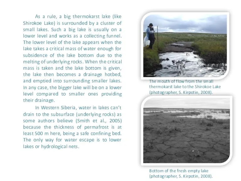
As a rule, a big thermokarst lake (like Shirokoe Lake) is
As a rule, a big thermokarst lake (like Shirokoe Lake) is
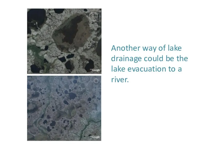
Another way of lake drainage could be the lake evacuation to
Another way of lake drainage could be the lake evacuation to
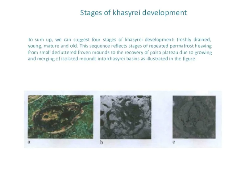
Stages of khasyrei development
To sum up, we can suggest four stages
Stages of khasyrei development
To sum up, we can suggest four stages
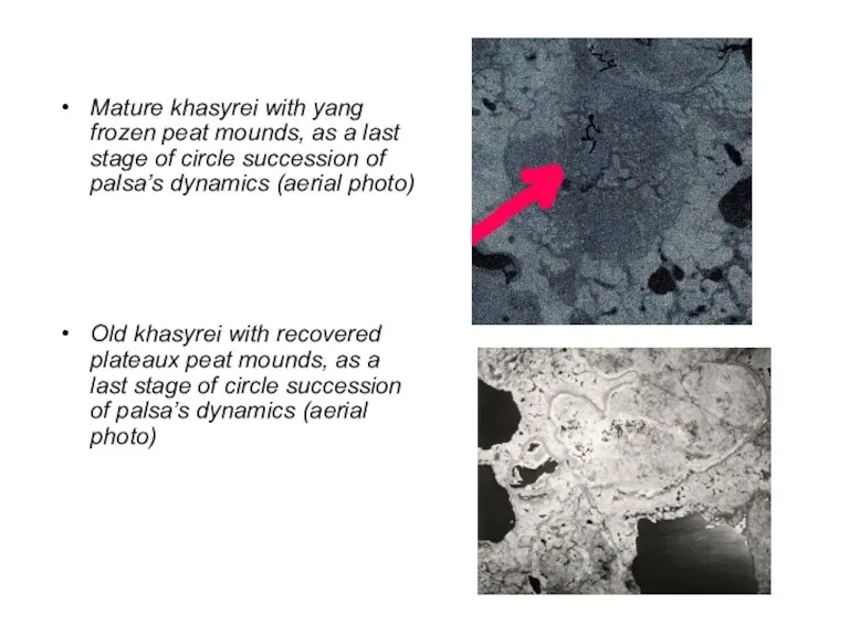
Mature khasyrei with yang frozen peat mounds, as a last stage
Mature khasyrei with yang frozen peat mounds, as a last stage
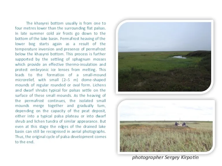
The khasyrei bottom usually is from one to four metres lower
The khasyrei bottom usually is from one to four metres lower
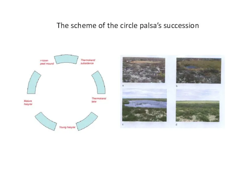
The scheme of the circle palsa’s succession
The scheme of the circle palsa’s succession
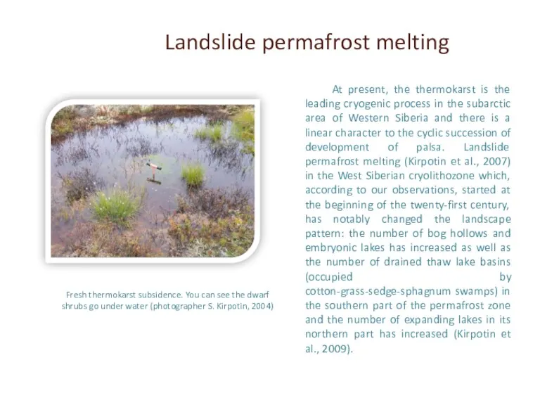
Fresh thermokarst subsidence. You can see the dwarf shrubs go under
Fresh thermokarst subsidence. You can see the dwarf shrubs go under
The rest of melting frozen mounds surrounded by rings of water
The rest of melting frozen mounds surrounded by rings of water
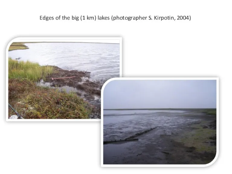
Edges of the big (1 km) lakes (photographer S. Kirpotin, 2004)
Edges of the big (1 km) lakes (photographer S. Kirpotin, 2004)
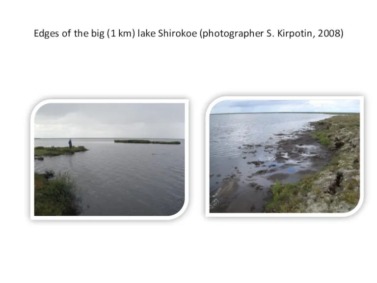
Edges of the big (1 km) lake Shirokoe (photographer S. Kirpotin,
Edges of the big (1 km) lake Shirokoe (photographer S. Kirpotin,
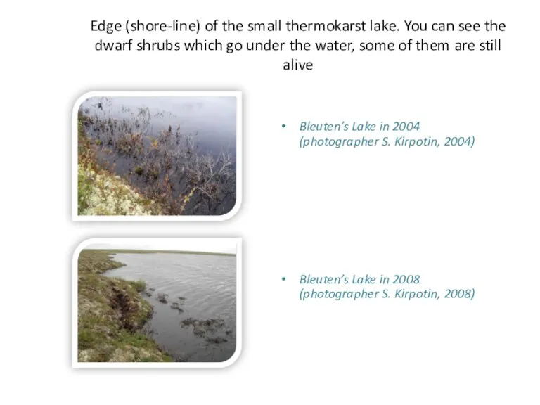
Edge (shore-line) of the small thermokarst lake. You can see the
Edge (shore-line) of the small thermokarst lake. You can see the
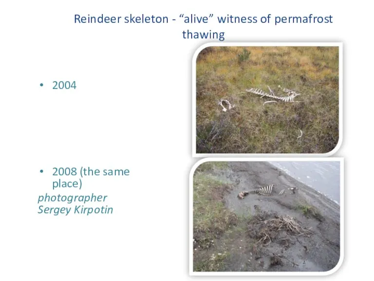
Reindeer skeleton - “alive” witness of permafrost thawing
2004
2008 (the same
Reindeer skeleton - “alive” witness of permafrost thawing
2004
2008 (the same
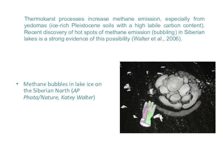
Thermokarst processes increase methane emission, especially from yedomas (ice-rich Pleistocene soils
Thermokarst processes increase methane emission, especially from yedomas (ice-rich Pleistocene soils
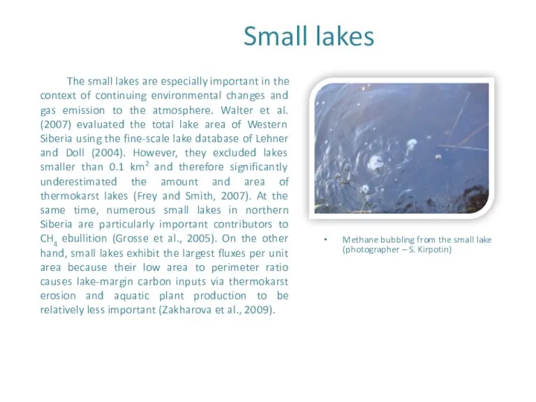
Small lakes
The small lakes are especially important in the context of
Small lakes
The small lakes are especially important in the context of
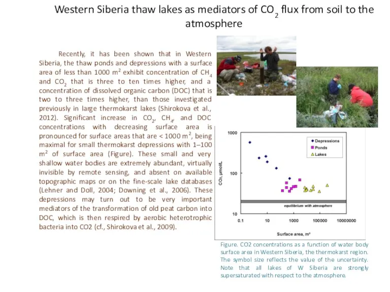
Western Siberia thaw lakes as mediators of CO2 flux from soil
Western Siberia thaw lakes as mediators of CO2 flux from soil
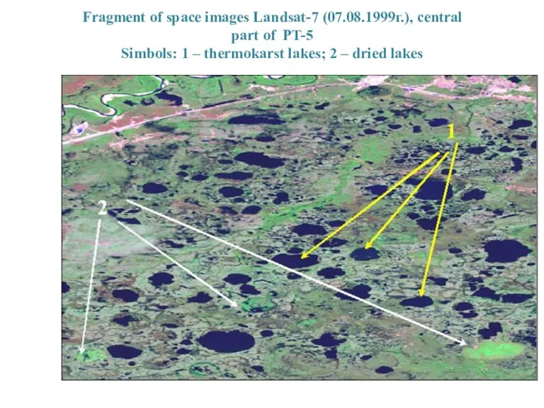
Fragment of space images Landsat-7 (07.08.1999г.), central
part of PT-5
Simbols:
part of PT-5
Simbols:
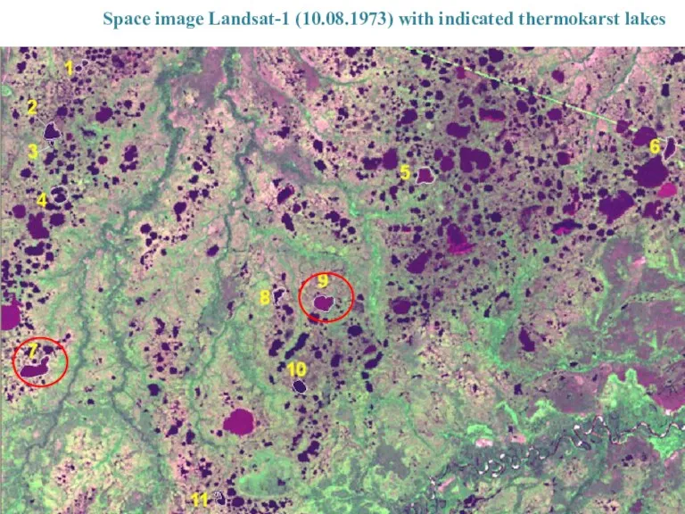
Space image Landsat-1 (10.08.1973) with indicated thermokarst lakes
Space image Landsat-1 (10.08.1973) with indicated thermokarst lakes
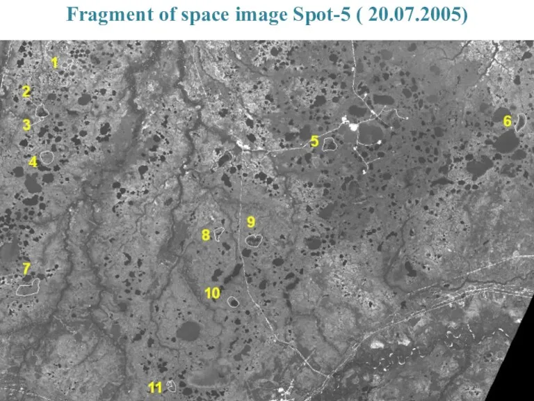
Fragment of space image Spot-5 ( 20.07.2005)
Fragment of space image Spot-5 ( 20.07.2005)
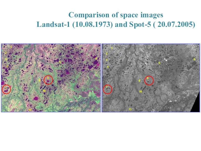
Comparison of space images
Landsat-1 (10.08.1973) and Spot-5 ( 20.07.2005)
Comparison of space images
Landsat-1 (10.08.1973) and Spot-5 ( 20.07.2005)
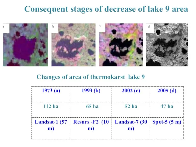
Consequent stages of decrease of lake 9 area
Changes of area of
Consequent stages of decrease of lake 9 area
Changes of area of
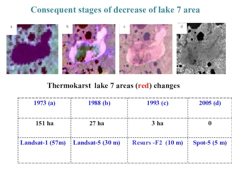
Consequent stages of decrease of lake 7 area
Thermokarst lake 7 areas
Consequent stages of decrease of lake 7 area
Thermokarst lake 7 areas
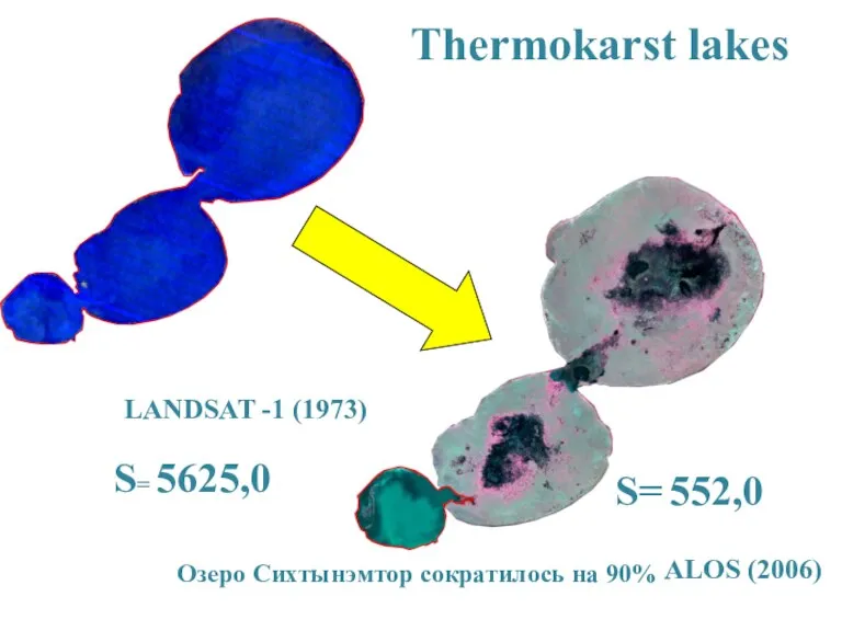
S= 5625,0
S= 552,0
LANDSAT -1 (1973)
ALOS (2006)
Thermokarst lakes
Озеро Сихтынэмтор сократилось на 90%
S= 5625,0
S= 552,0
LANDSAT -1 (1973)
ALOS (2006)
Thermokarst lakes
Озеро Сихтынэмтор сократилось на 90%
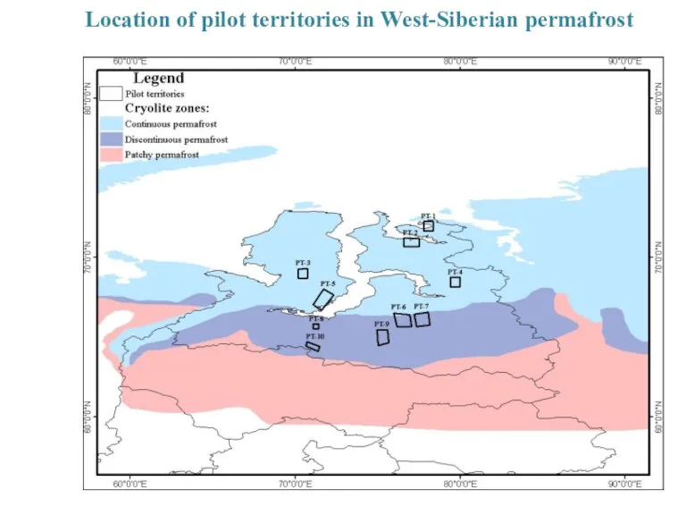
Location of pilot territories in West-Siberian permafrost
Location of pilot territories in West-Siberian permafrost
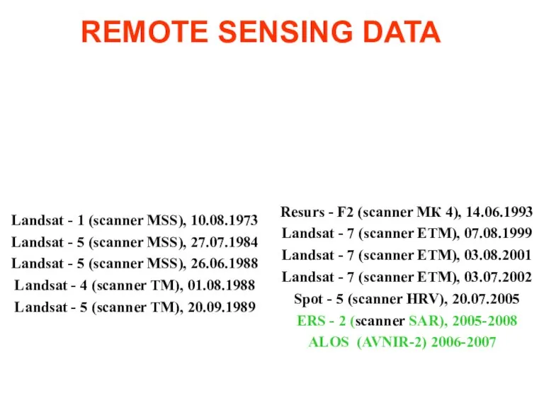
Landsat - 1 (scanner MSS), 10.08.1973
Landsat - 5 (scanner MSS), 27.07.1984
Landsat
Landsat - 1 (scanner MSS), 10.08.1973
Landsat - 5 (scanner MSS), 27.07.1984
Landsat
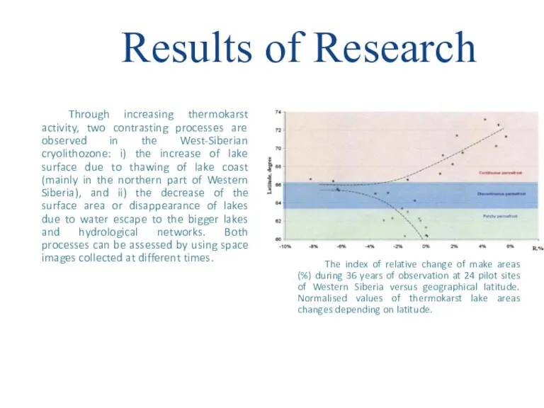
Through increasing thermokarst activity, two contrasting processes are observed in the
Through increasing thermokarst activity, two contrasting processes are observed in the

International projects
Currently our Centre participate in the EU JPI-Climate Project: Climate
International projects
Currently our Centre participate in the EU JPI-Climate Project: Climate
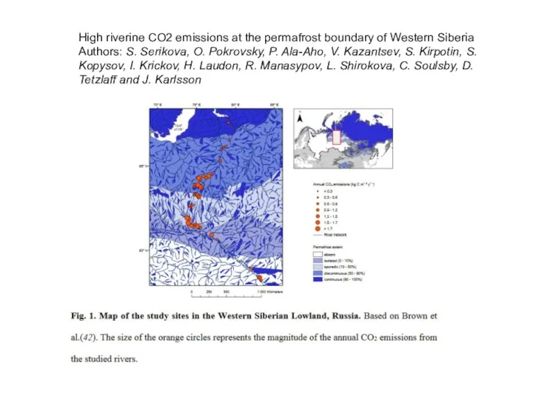
High riverine CO2 emissions at the permafrost boundary of Western Siberia
Authors:
High riverine CO2 emissions at the permafrost boundary of Western Siberia
Authors:
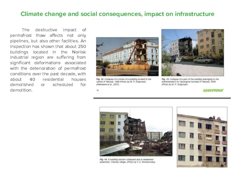
Climate change and social consequences, impact on infrastructure
The destructive impact
Climate change and social consequences, impact on infrastructure
The destructive impact
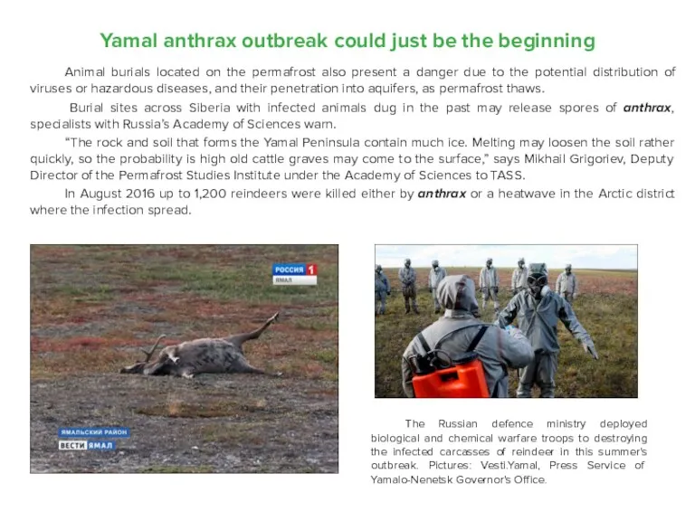
Yamal anthrax outbreak could just be the beginning
Animal burials located on
Yamal anthrax outbreak could just be the beginning
Animal burials located on
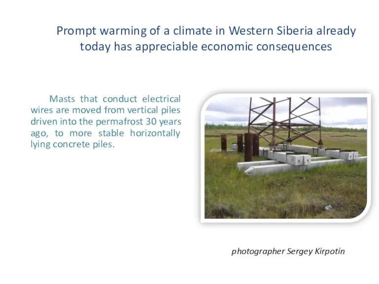
Prompt warming of a climate in Western Siberia already today has
Prompt warming of a climate in Western Siberia already today has
 Конкурентоспособность предприятия на примере филиала ОАО “Беллифт” “Беллифтмонтаж”
 Инновационная и инвестиционная деятельность предприятия. (Тема 10)
 Урок-обобщение по теме Бюджет и бюджетные отношения
 История экономической мысли
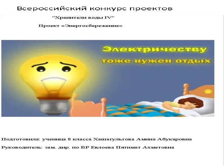 Всероссийский конкурс проектов Хранители воды IV. Проект Энергосбережение
 Рынки факторов производства
 Промышленный комплекс Беларуси
 Постсоветское пространство: Центральная Азия
 Технико-экономическое обоснование инвестиционных проектов
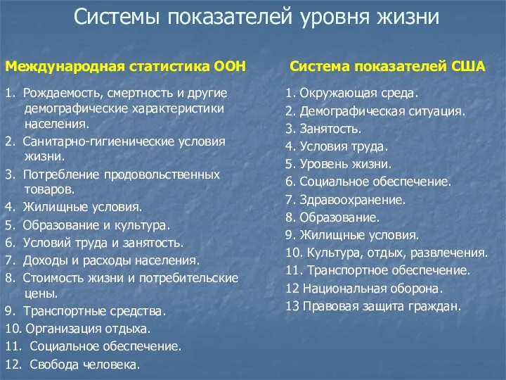 Системы показателей уровня жизни
 Прогнозирование и планирование в государственном регулирования экономики. (Лекция 3)
 Рыночные отношения в экономике
 Критерии и показатели экономической безопасности государства
 Распределение доходов в рыночной экономике. Тема 7
 Дүниежүзілік шаруашылықтың қалыптасуы және оның кұрылымы
 Сыртқы экономикалық қызмет субъектілерін жіктеп көрсету, кепілдіктерінің мәнін терең ашып түсіндіру
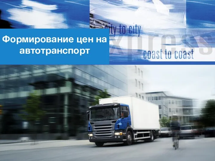 Формирование цен на автотранспорт. Преимущества автотранспорта
 Предприятие – основное звено экономики
 Ограниченность экономических ресурсов и порождаемые ею проблемы
 Морской порт Тамань
 Американский институционализм. (Лекция 6)
 Volkswagen company
 Распад плановой экономики 90-ых годов и переход на рыночние рельсы в России
 Список источников по экономике
 ГонкОПТ. Стратегия развития компании на 2018-2019 годы
 Теория Мальтуса
 Система туризма
 Энергосбережение в быту