- Stratigraphy and Correlation

Содержание
- 2. Content Data, Stratigraphy and Models Graphic Correlation Reservoir Architecture and Reservoir Performance Exercises
- 3. Introduction Correlation – the identification of certain intervals in one well which relate to equivalent intervals
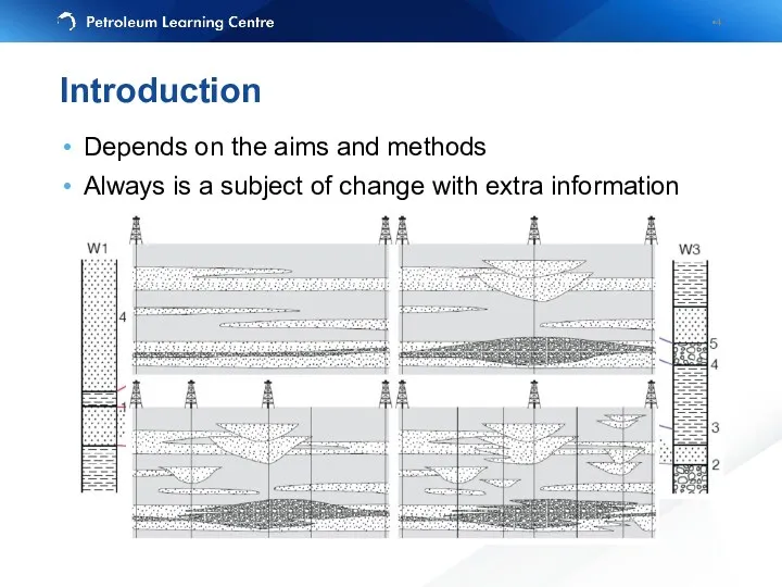
- 4. Introduction Depends on the aims and methods Always is a subject of change with extra information
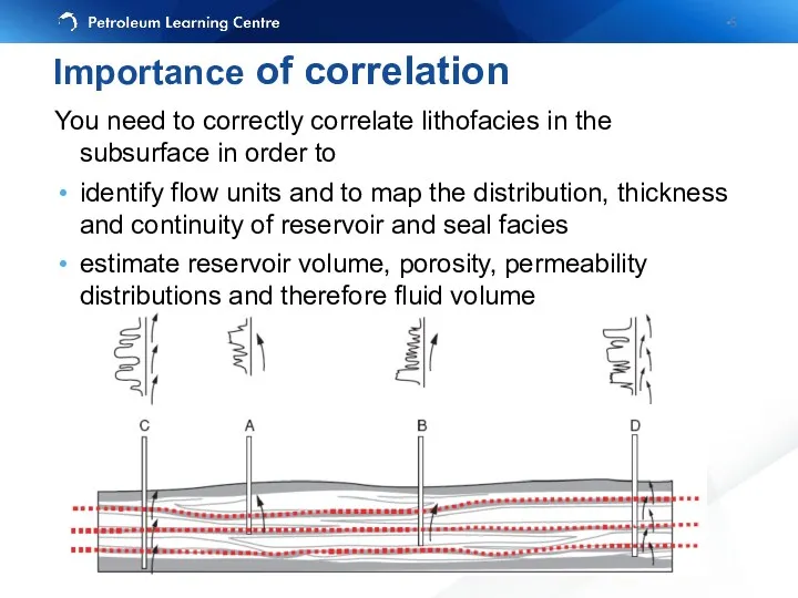
- 5. Importance of correlation You need to correctly correlate lithofacies in the subsurface in order to identify
- 6. Wireline logs (well tops and lithology) are is a primary (hard) data (usually needs preparation) Biostratigraphic
- 7. Compare the complexity of Helder and Hoorn Fields (Roelofsen et al., 1991) Data
- 8. Wire log data transformation to True Vertical Depth (TVD) or TVDSS (subsea) KB Vertical distance from
- 9. Why normalize scales? MD gives thicker units than TVD, meaning that correlations drawn using MD are
- 10. Caliper – кавернометрия, результатом измерения является кавернограмма — кривая, отражающая изменение диаметра скважины с глубиной. Mud
- 11. Different purpose – GR – lithology (sand vs clay) – Resistivity – saturation character and quantity
- 12. Lithostratigraphy: most widely used (still), allows arrangeing facies, porosity and permeability zones. / раздел стратиграфии, использующий
- 13. Uniformitarianism: The present is the key to past Sedimentary rocks are deposited horizontally Sedimentary beds continue
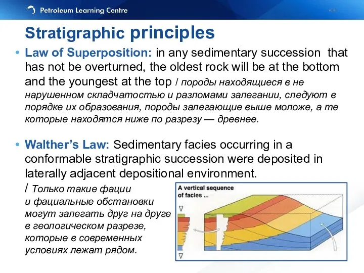
- 14. Law of Superposition: in any sedimentary succession that has not be overturned, the oldest rock will
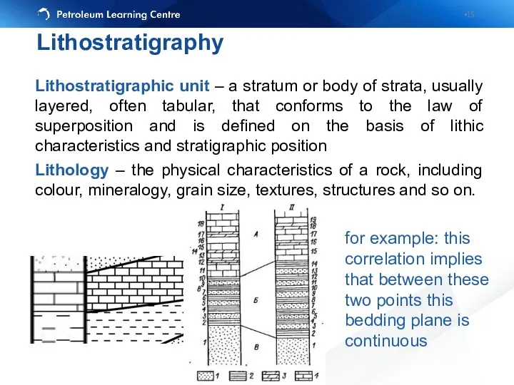
- 15. Lithostratigraphic unit – a stratum or body of strata, usually layered, often tabular, that conforms to
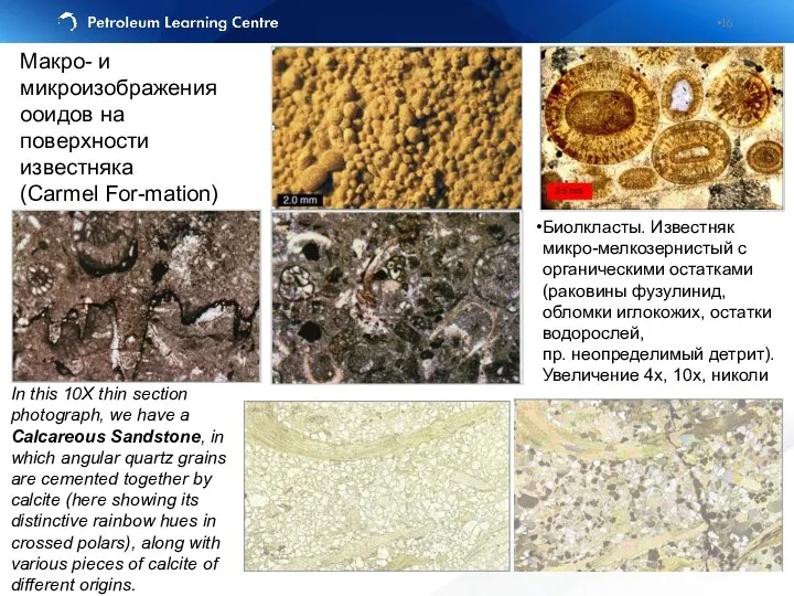
- 16. In this 10X thin section photograph, we have a Calcareous Sandstone, in which angular quartz grains
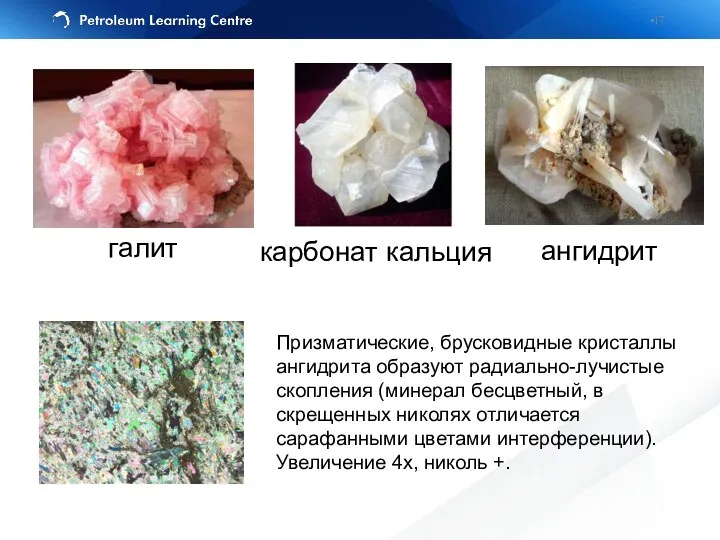
- 17. галит карбонат кальция ангидрит Призматические, брусковидные кристаллы ангидрита образуют радиально-лучистые скопления (минерал бесцветный, в скрещенных николях
- 18. The same lithology does not always mean that the rocks were deposited at the same time,
- 19. Formal lithostratigraphic terms in increasing scale: – Member (пачка) - smallest locally mappable unit (within field)
- 20. MZ-KZ PZ В строении Западно-Сибирской нефтегазоносной провинции принимают участие метаморфизованный фундамент докембрийско-палеозойского возраста и полого залегающий
- 21. Stratigraphic section of Mesozoic rocks of West Siberian basin (Gregory F. Ulmishek) Stratigraphic section of Mesozoic
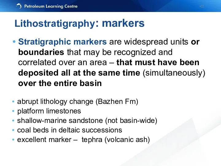
- 22. Stratigraphic markers are widespread units or boundaries that may be recognized and correlated over an area
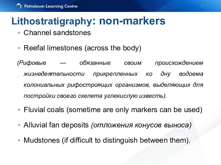
- 23. Channel sandstones Reefal limestones (across the body) (Рифовые — обязанные своим происхождением жизнедеятельности прикрепленных ко дну
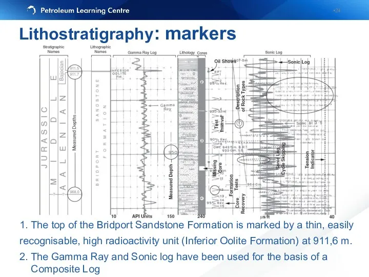
- 24. Lithostratigraphy: markers 1. The top of the Bridport Sandstone Formation is marked by a thin, easily
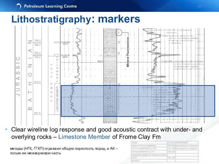
- 25. Clear wireline log response and good acoustic contract with under- and overlying rocks – Limestone Member
- 26. Well №1 shows reduced section because of normal fault penetrated Dipmeter would be useful to recognize
- 27. True succession Drilled succession Repeated sections: reverse faults (from Tearpock and Bischke, 1991) Dipmeter would be
- 28. Beware of probable differences in resistivity logs response due to the saturation Always correlate from the
- 29. Sandstone Siltstone Limestone Conglo-merate Correlate the different lithological units represented here Exercise 1. Lithostratigaphical correlation
- 30. This is one of possible answers Exercise 1. Lithostratigaphical correlation
- 31. We have decided that the subsurface in the region represented by these three logs looks something
- 32. Biostratigraphic unit – a body of rock defined on the basis of its fossil content Link
- 33. Biostratigraphical correlation
- 34. Correlate the biostratigraphic markers represented by the symbols (first and last appearance of the organisms) Корреляция
- 35. Exercise 2. Biostratigaphical correlation
- 36. Magnetic minerals in sedimentary rocks tend to be deposited according to the Earth magnetic field Earth
- 37. Магнитное поле Земли или геомагнитное поле — магнитное поле, генерируемое внутриземными источниками. Точки Земли, в которых
- 38. Общая магнито-стратиграфическая шкала (англ. general magnetostratigraphic scale) – хронологическая последовательность магнитозон полярности, привязанная к подразделениям Общей
- 39. Черный цвет - нормальная намагниченность, белый цвет - обратная намагниченность Exercise 3. Magnetostratigraphical correlation
- 40. Exercise 3. Magnetostratigraphical correlation
- 41. Formal chronostratigraphic terms in increasing length of time: – Stage - smallest unit of defined time
- 42. Chronostratigraphy vs. Lithostratigraphy
- 44. Seismic Stratigraphy Correlation of seismic packages bounded by truncations of reflection events Advantages - Continuous interpretation
- 45. Reservoir Limits Stratigraphic pinch-out of reservoir unit (Thompson and Butcher, 1991)
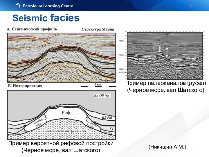
- 46. Пример вероятной рифовой постройки (Черное море, вал Шатского) Пример палеоканалов (русел) (Черное море, вал Шатского) (Никишин
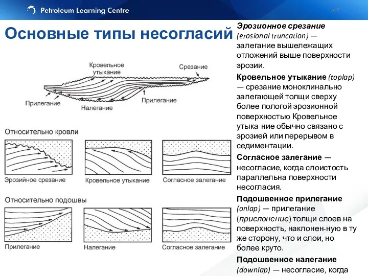
- 47. Эрозионное срезание (erosional truncation) — залегание вышележащих отложений выше поверхности эрозии. Кровельное утыкание (toplap) — срезание
- 48. Initial Interpretation Final Results Raw Data
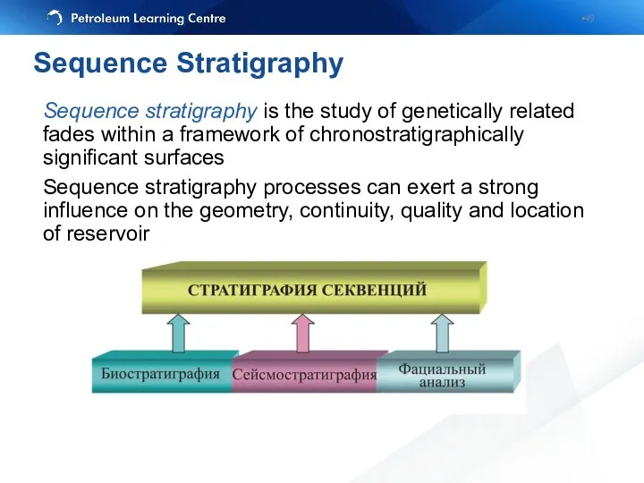
- 49. Sequence stratigraphy is the study of genetically related fades within a framework of chronostratigraphically significant surfaces
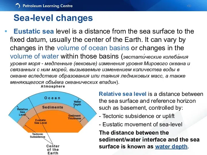
- 50. Eustatic sea level is a distance from the sea surface to the fixed datum, usually the
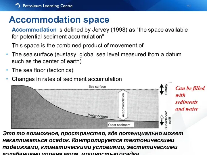
- 51. Accommodation is defined by Jervey (1998) as "the space available for potential sediment accumulation" This space
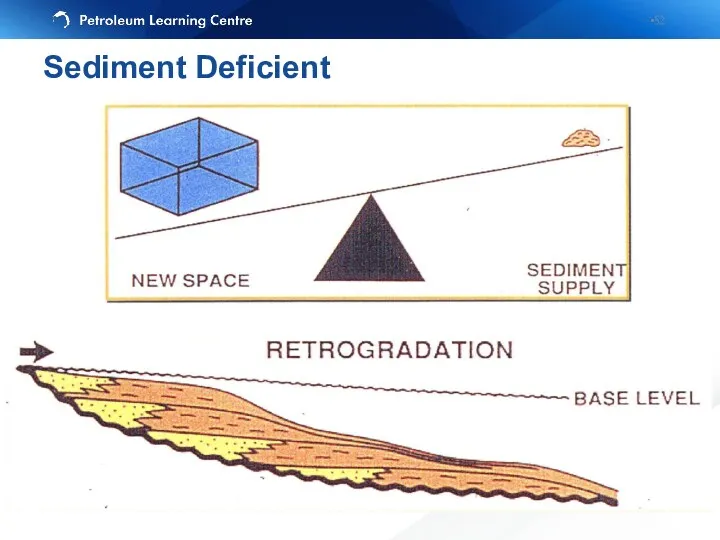
- 52. Sediment Deficient
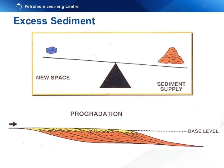
- 53. Excess Sediment
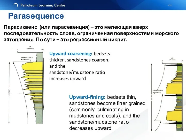
- 54. Upward-fining: bedsets thin, sandstones become finer grained (commonly culminating in mudstones and coals), and the sandstone/mudstone
- 55. Проградационный пакет парасеквенций направлен в сторону бассейна и носит регрессивный характер. Ретроградационный направлен в противоположную сторону
- 56. Chronostratigraphy vs. Lithostratigraphy Progradational parasequence set
- 57. Chronostratigraphy vs. Lithostratigraphy Retrogradational parasequence set
- 58. Принципиальная схема строения клиноформ неокома Западной Сибири (по А.А. Нежданову и др., 2000).
- 59. “A sequence is a stratigraphic unit composed of a relatively conformable succession of genetically related strata
- 60. LST = Lowstand Systems Tract: sea level drop, continental shelf subaeral erosion, shelf margin wedge, facies
- 61. TST = Transgressive Systems Tract: sea level rise, maximum flooding surface (MFS), facies boundaries shift towards
- 62. HST = Highstand Systems Tract (sometime Regressive Systems Tract): sea level rise, stabilizing and starting to
- 63. High sea-level: Flooding surfaces Deposition of reservoir close to shore Reservoir marker events – marine shales
- 64. The subaerial unconformity is an unconformity that forms under subaerial conditions as a result of fluvial
- 65. Stratal elements in Hierarchy
- 66. continental: megasequence supersequence basin: sequence depositional systems tract parasequence set reservoir: parasequence bedset bed laminaset lamina
- 67. continental: megasequence supersequence basin: sequence depositional systems tract parasequence set reservoir: parasequence bedset bed laminaset lamina
- 68. Sequence Stratigraphy Terminology
- 69. Терминология
- 70. Accurate correlations depends on a little knowledge of the environment of deposition of the sediments: “In
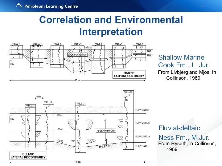
- 71. Shallow Marine Cook Fm., L. Jur. Fluvial-deltaic Ness Fm., M.Jur. From Livbjerg and Mjos, in Collinson,
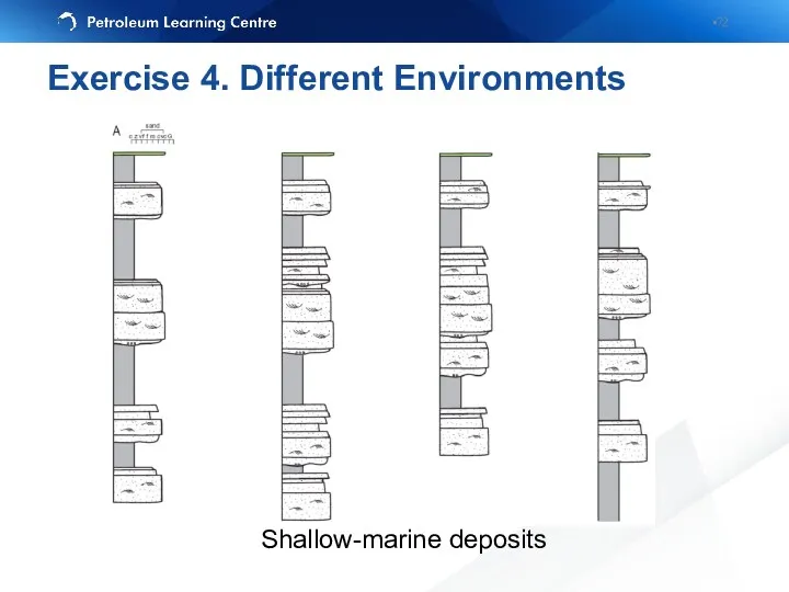
- 72. Shallow-marine deposits Exercise 4. Different Environments
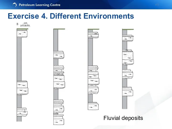
- 73. Fluvial deposits Exercise 4. Different Environments
- 74. Exercise 4. Different Environments
- 75. Impossible scenario Realism in correlations
- 76. Stratigraphic relationships are easier to display if you align the logs so that correlated rocks or
- 77. A correlation panel: equally spaced wells wells have been hung A cross-section: spacing of wells reflects
- 78. Correlation panel
- 79. Cross-section
- 80. Fence diagram: actual position of the wells Graphic Correlation
- 81. Block-diagram (well location needed) – either 3-D image of current geology/geography, or interpretations of facies relationships,
- 82. Use the log patterns to correlate, but beware of differences caused by fluid effects on the
- 83. Non-geological features
- 84. Correlating wireline logs
- 85. Flow unit is a mappable portion of total reservoir within which geological and petrophysical properties that
- 86. Flow units concepts: Have the same petrophysical properties Recognizable on logs and correlatable between wells Include
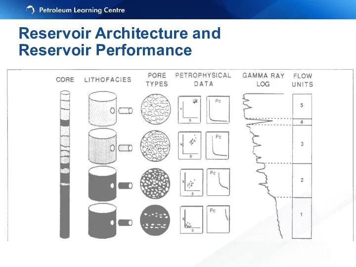
- 87. Reservoir Architecture and Reservoir Performance
- 88. Layercake – Layered reservoirs: Low permeability contrasts between vertically stacked layers which are laterally extensive Three
- 89. Deterministic model can be used for correlation Simple to model Reservoir Architecture
- 90. Deterministic model hardly can be used for correlation – probably stochastic approach (or combination of both)
- 91. Connectivity between sand bodies is related to the proportion of sand in the vertical section The
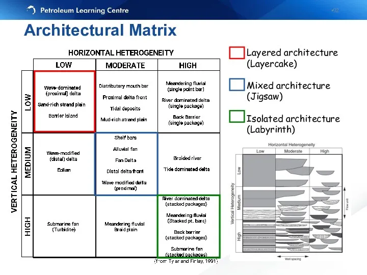
- 92. Layered architecture (Layercake) Mixed architecture (Jigsaw) Isolated architecture (Labyrinth) Architectural Matrix
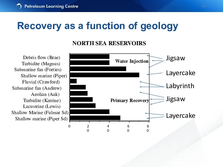
- 93. Layercake Labyrinth Jigsaw Layercake Jigsaw NORTH SEA RESERVOIRS Primary Recovery Water Injection Recovery as a function
- 94. Sedimentary structures or stratal architecture (facies models) Turbidites (Forties), fluvial reservoirs (Brent Ness Formation), deltas etc…
- 95. Learning objectives Identify correlation markers Correlate lithological units between wells using lithology and wireline log information
- 96. It involves: 6: Correlation and hanging 7: Faulted sections 8: Structural vs stratigraphic cross-sections Exercise 6-8:
- 97. Дополнительные слайды
- 98. Эрозионное срезание (erosional truncation) — залегание вышележащих отложений выше поверхности эрозии. Может встречаться в разных позициях
- 99. Seismic unconformities
- 101. Скачать презентацию
Content
Data, Stratigraphy and Models
Graphic Correlation
Reservoir Architecture and Reservoir Performance
Exercises
Content
Data, Stratigraphy and Models
Graphic Correlation
Reservoir Architecture and Reservoir Performance
Exercises
Introduction
Correlation – the identification of certain intervals in one well which
Introduction
Correlation – the identification of certain intervals in one well which
Introduction
Depends on the aims and methods
Always is a subject of change
Introduction
Depends on the aims and methods
Always is a subject of change
Importance of correlation
You need to correctly correlate lithofacies in the subsurface
Importance of correlation
You need to correctly correlate lithofacies in the subsurface
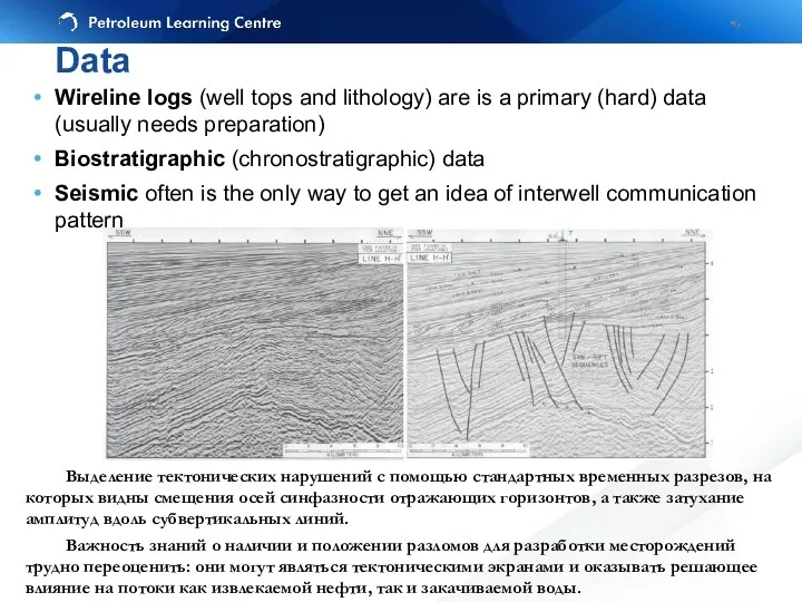
Wireline logs (well tops and lithology) are is a primary (hard)
Wireline logs (well tops and lithology) are is a primary (hard)
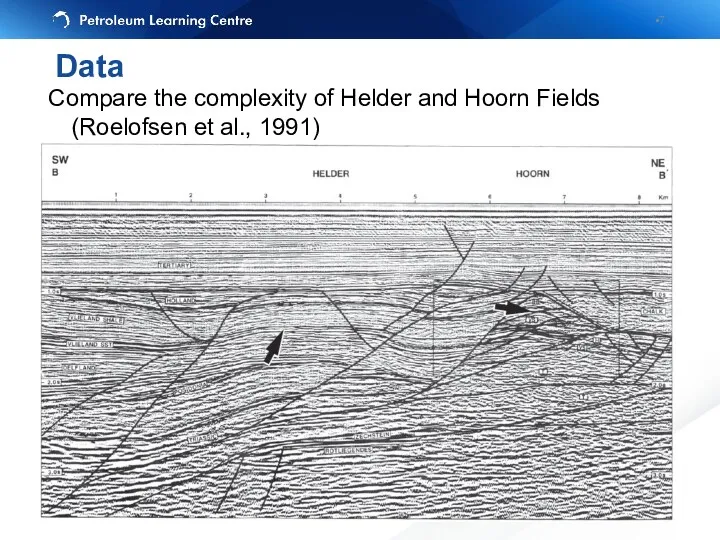
Compare the complexity of Helder and Hoorn Fields (Roelofsen et al.,
Compare the complexity of Helder and Hoorn Fields (Roelofsen et al.,
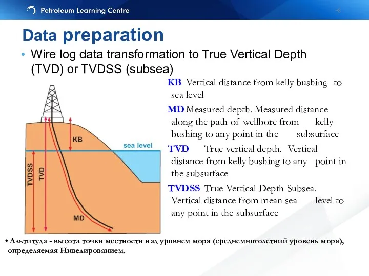
Wire log data transformation to True Vertical Depth (TVD) or TVDSS
Wire log data transformation to True Vertical Depth (TVD) or TVDSS
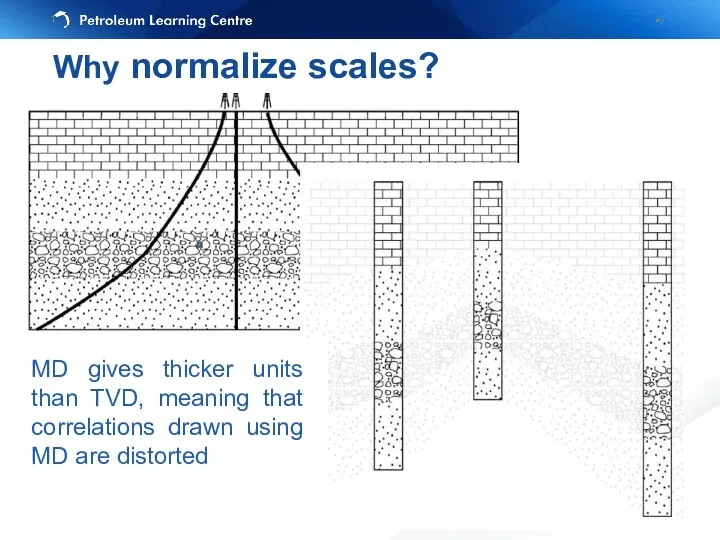
Why normalize scales?
MD gives thicker units than TVD, meaning that correlations
Why normalize scales?
MD gives thicker units than TVD, meaning that correlations
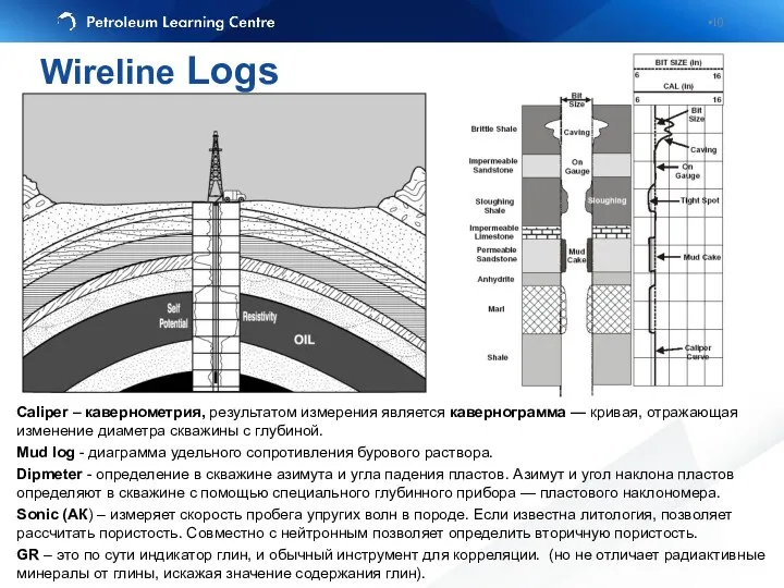
Caliper – кавернометрия, результатом измерения является кавернограмма — кривая, отражающая изменение
Caliper – кавернометрия, результатом измерения является кавернограмма — кривая, отражающая изменение
Different purpose
– GR – lithology (sand vs clay)
– Resistivity – saturation
Different purpose
– GR – lithology (sand vs clay)
– Resistivity – saturation
Lithostratigraphy: most widely used (still), allows arrangeing facies, porosity and permeability
Lithostratigraphy: most widely used (still), allows arrangeing facies, porosity and permeability
Uniformitarianism: The present is the key to past
Sedimentary rocks are deposited
Uniformitarianism: The present is the key to past
Sedimentary rocks are deposited
Law of Superposition: in any sedimentary succession that has not be
Law of Superposition: in any sedimentary succession that has not be
Lithostratigraphic unit – a stratum or body of strata, usually layered,
Lithostratigraphic unit – a stratum or body of strata, usually layered,
In this 10X thin section photograph, we have a Calcareous Sandstone,
In this 10X thin section photograph, we have a Calcareous Sandstone,
галит
карбонат кальция
ангидрит
Призматические, брусковидные кристаллы ангидрита образуют радиально-лучистые скопления (минерал бесцветный, в
галит
карбонат кальция
ангидрит
Призматические, брусковидные кристаллы ангидрита образуют радиально-лучистые скопления (минерал бесцветный, в
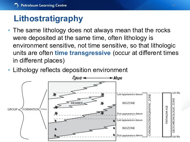
The same lithology does not always mean that the rocks were
The same lithology does not always mean that the rocks were
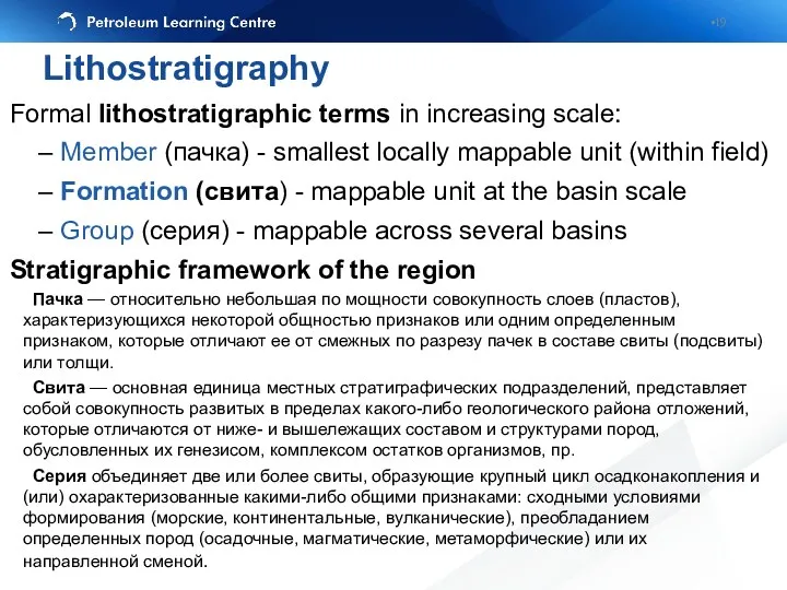
Formal lithostratigraphic terms in increasing scale:
– Member (пачка) - smallest
Formal lithostratigraphic terms in increasing scale:
– Member (пачка) - smallest
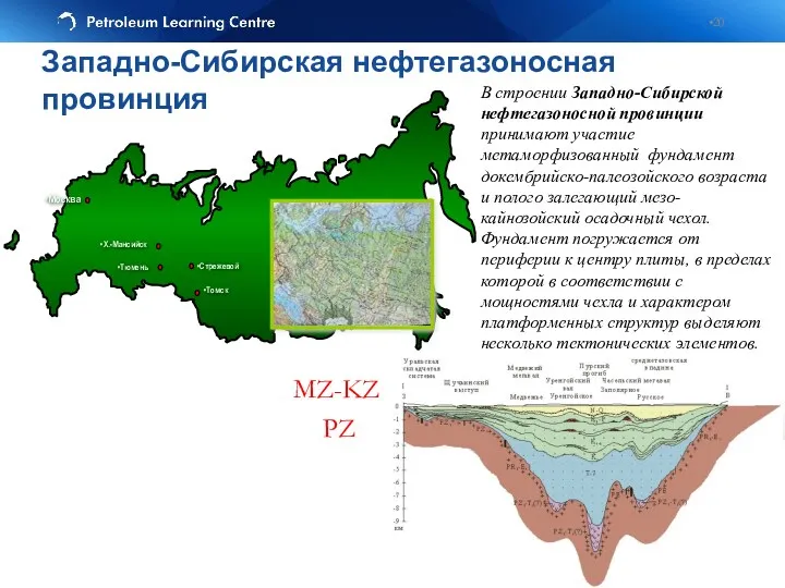
MZ-KZ
PZ
В строении Западно-Сибирской нефтегазоносной провинции принимают участие метаморфизованный фундамент докембрийско-палеозойского возраста
MZ-KZ
PZ
В строении Западно-Сибирской нефтегазоносной провинции принимают участие метаморфизованный фундамент докембрийско-палеозойского возраста
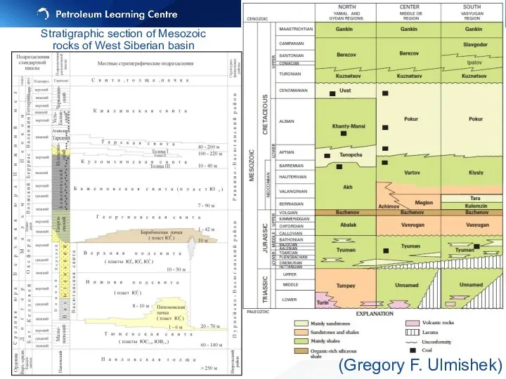
Stratigraphic section of Mesozoic rocks of West Siberian basin
(Gregory F. Ulmishek)
Stratigraphic
Stratigraphic section of Mesozoic rocks of West Siberian basin
(Gregory F. Ulmishek)
Stratigraphic
Stratigraphic markers are widespread units or boundaries that may be recognized
Stratigraphic markers are widespread units or boundaries that may be recognized
Channel sandstones
Reefal limestones (across the body)
(Рифовые — обязанные своим происхождением жизнедеятельности
Channel sandstones
Reefal limestones (across the body)
(Рифовые — обязанные своим происхождением жизнедеятельности
Lithostratigraphy: markers
1. The top of the Bridport Sandstone Formation is marked
Lithostratigraphy: markers
1. The top of the Bridport Sandstone Formation is marked
Clear wireline log response and good acoustic contract with under- and
Clear wireline log response and good acoustic contract with under- and
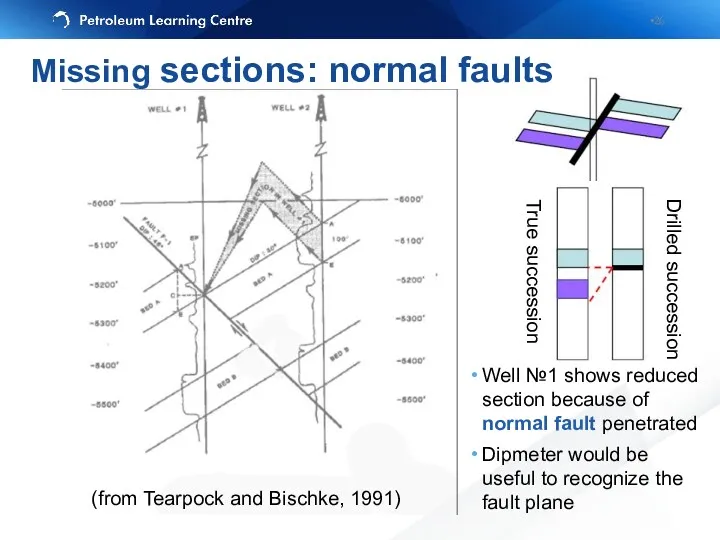
Well №1 shows reduced section because of normal fault penetrated
Dipmeter would
Well №1 shows reduced section because of normal fault penetrated
Dipmeter would
True succession
Drilled succession
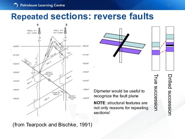
Repeated sections: reverse faults
(from Tearpock and Bischke, 1991)
Dipmeter would
True succession
Drilled succession
Repeated sections: reverse faults
(from Tearpock and Bischke, 1991)
Dipmeter would
Beware of probable differences in resistivity logs response due to the
Beware of probable differences in resistivity logs response due to the
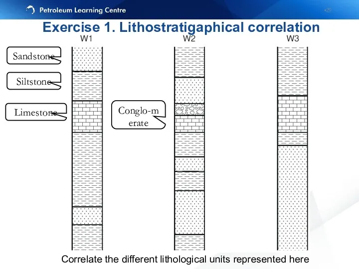
Sandstone
Siltstone
Limestone
Conglo-merate
Correlate the different lithological units represented here
Exercise 1. Lithostratigaphical correlation
Sandstone
Siltstone
Limestone
Conglo-merate
Correlate the different lithological units represented here
Exercise 1. Lithostratigaphical correlation
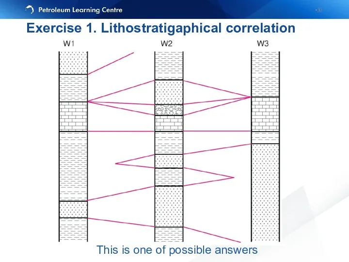
This is one of possible answers
Exercise 1. Lithostratigaphical correlation
This is one of possible answers
Exercise 1. Lithostratigaphical correlation
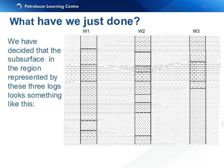
We have decided that the subsurface in the region represented by
We have decided that the subsurface in the region represented by
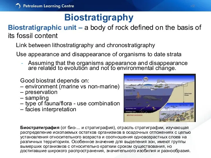
Biostratigraphic unit – a body of rock defined on the basis
Biostratigraphic unit – a body of rock defined on the basis
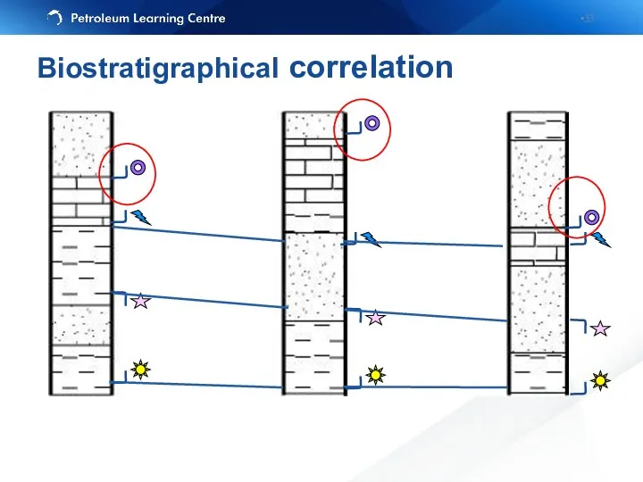
Biostratigraphical correlation
Biostratigraphical correlation
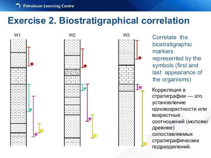
Correlate the biostratigraphic markers represented by the symbols (first and last
Correlate the biostratigraphic markers represented by the symbols (first and last
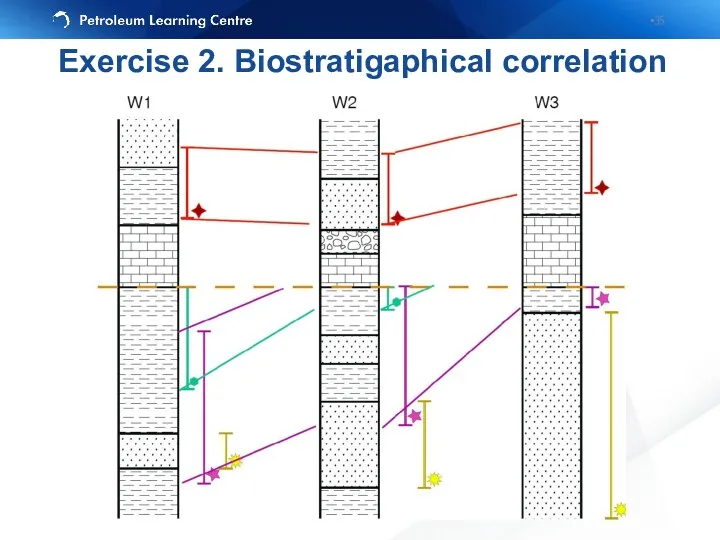
Exercise 2. Biostratigaphical correlation
Exercise 2. Biostratigaphical correlation
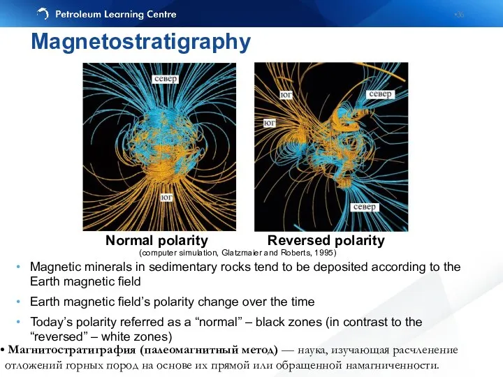
Magnetic minerals in sedimentary rocks tend to be deposited according to
Magnetic minerals in sedimentary rocks tend to be deposited according to
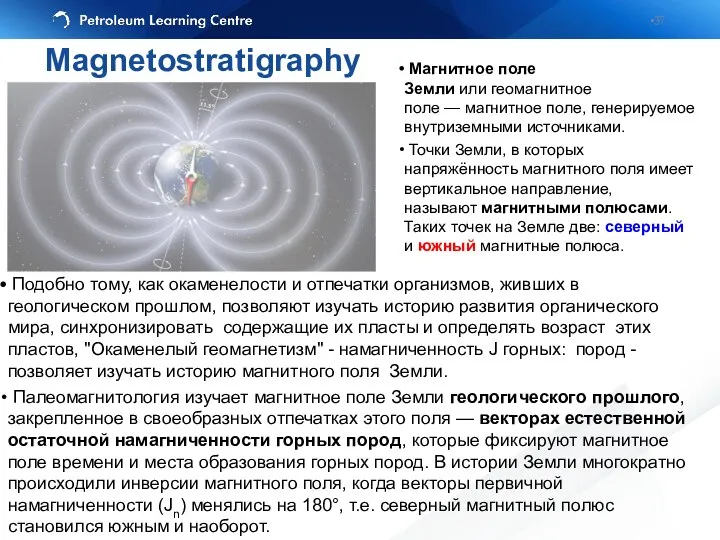
Магнитное поле Земли или геомагнитное поле — магнитное поле, генерируемое внутриземными источниками.
Точки Земли,
Магнитное поле Земли или геомагнитное поле — магнитное поле, генерируемое внутриземными источниками.
Точки Земли,
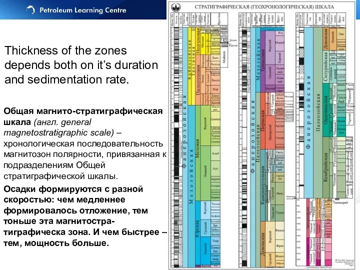
Общая магнито-стратиграфическая шкала (англ. general magnetostratigraphic scale) – хронологическая последовательность магнитозон полярности, привязанная
Общая магнито-стратиграфическая шкала (англ. general magnetostratigraphic scale) – хронологическая последовательность магнитозон полярности, привязанная
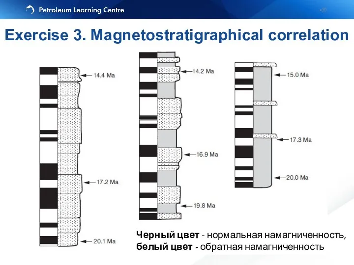
Черный цвет - нормальная намагниченность, белый цвет - обратная намагниченность
Exercise 3.
Черный цвет - нормальная намагниченность, белый цвет - обратная намагниченность
Exercise 3.
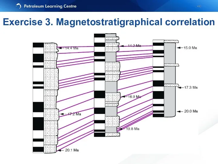
Exercise 3. Magnetostratigraphical correlation
Exercise 3. Magnetostratigraphical correlation
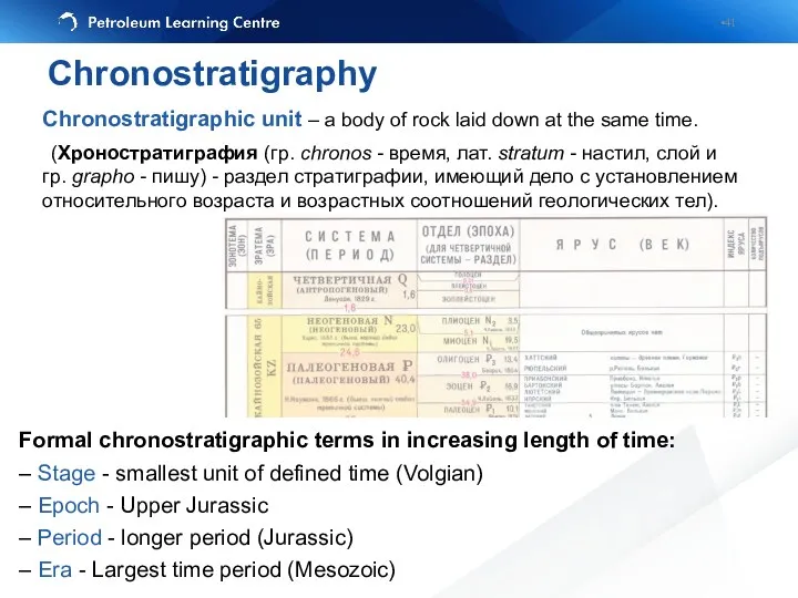
Formal chronostratigraphic terms in increasing length of time:
– Stage - smallest
Formal chronostratigraphic terms in increasing length of time:
– Stage - smallest
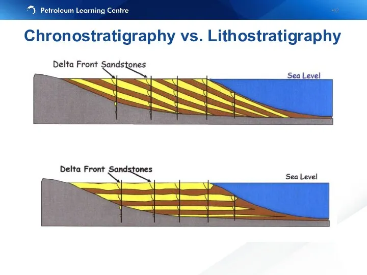
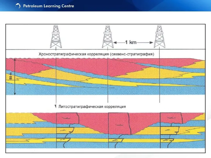
Chronostratigraphy vs. Lithostratigraphy
Chronostratigraphy vs. Lithostratigraphy
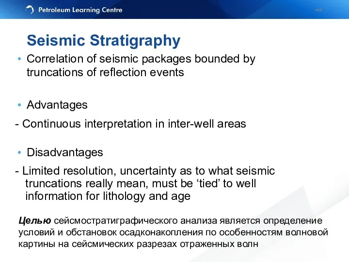
Seismic Stratigraphy
Correlation of seismic packages bounded by truncations of reflection events
Advantages
-
Seismic Stratigraphy
Correlation of seismic packages bounded by truncations of reflection events
Advantages
-
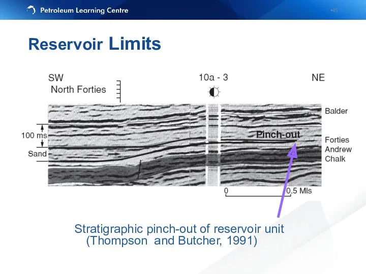
Reservoir Limits
Stratigraphic pinch-out of reservoir unit
(Thompson and Butcher, 1991)
Reservoir Limits
Stratigraphic pinch-out of reservoir unit
(Thompson and Butcher, 1991)
Пример вероятной рифовой постройки (Черное море, вал Шатского)
Пример палеоканалов (русел) (Черное
Пример вероятной рифовой постройки (Черное море, вал Шатского)
Пример палеоканалов (русел) (Черное
Эрозионное срезание (erosional truncation) — залегание вышележащих отложений выше поверхности эрозии.
Эрозионное срезание (erosional truncation) — залегание вышележащих отложений выше поверхности эрозии.
Initial Interpretation
Final Results
Raw Data
Initial Interpretation
Final Results
Raw Data
Sequence stratigraphy is the study of genetically related fades within a
Sequence stratigraphy is the study of genetically related fades within a
Eustatic sea level is a distance from the sea surface to
Eustatic sea level is a distance from the sea surface to
Accommodation is defined by Jervey (1998) as "the space available for
Accommodation is defined by Jervey (1998) as "the space available for
Sediment Deficient
Sediment Deficient
Excess Sediment
Excess Sediment
Upward-fining: bedsets thin, sandstones become finer grained (commonly culminating in mudstones
Upward-fining: bedsets thin, sandstones become finer grained (commonly culminating in mudstones
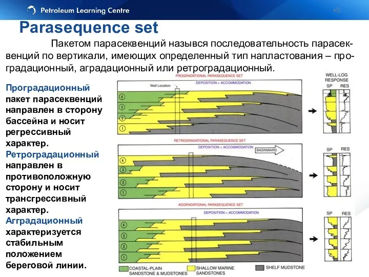
Проградационный пакет парасеквенций направлен в сторону бассейна и носит регрессивный характер.
Проградационный пакет парасеквенций направлен в сторону бассейна и носит регрессивный характер.
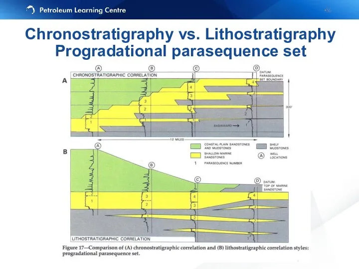
Chronostratigraphy vs. Lithostratigraphy
Progradational parasequence set
Chronostratigraphy vs. Lithostratigraphy
Progradational parasequence set
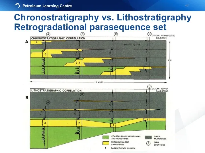
Chronostratigraphy vs. Lithostratigraphy
Retrogradational parasequence set
Chronostratigraphy vs. Lithostratigraphy
Retrogradational parasequence set
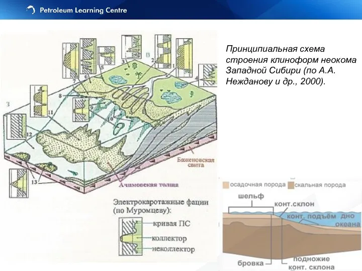
Принципиальная схема строения клиноформ неокома Западной Сибири (по А.А. Нежданову и
Принципиальная схема строения клиноформ неокома Западной Сибири (по А.А. Нежданову и
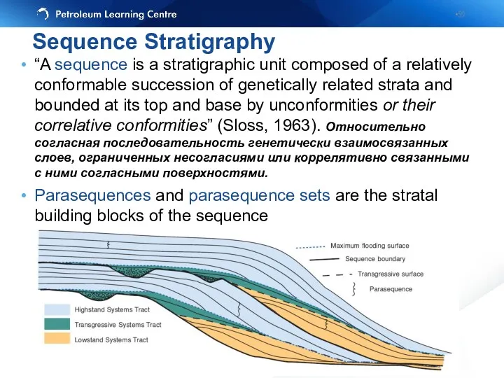
“A sequence is a stratigraphic unit composed of a relatively conformable
“A sequence is a stratigraphic unit composed of a relatively conformable
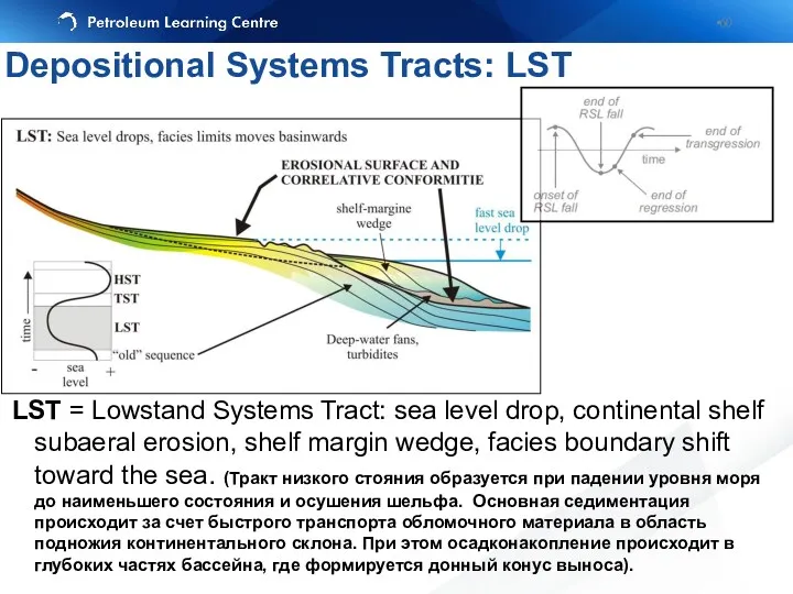
LST = Lowstand Systems Tract: sea level drop, continental shelf subaeral
LST = Lowstand Systems Tract: sea level drop, continental shelf subaeral
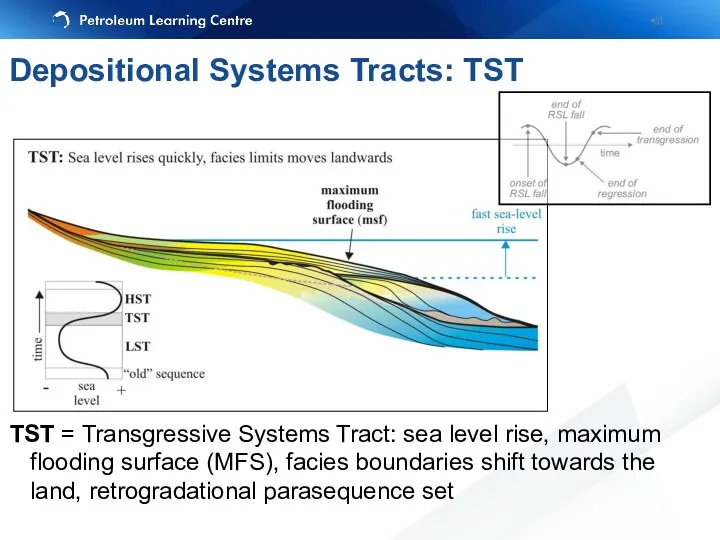
TST = Transgressive Systems Tract: sea level rise, maximum flooding surface
TST = Transgressive Systems Tract: sea level rise, maximum flooding surface
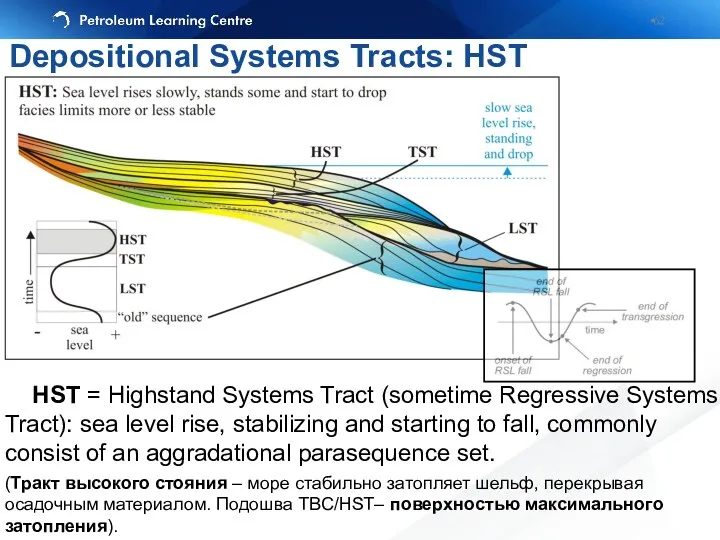
HST = Highstand Systems Tract (sometime Regressive Systems Tract): sea
HST = Highstand Systems Tract (sometime Regressive Systems Tract): sea
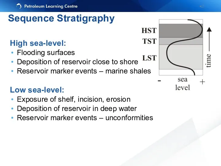
High sea-level:
Flooding surfaces
Deposition of reservoir close to shore
Reservoir marker events –
High sea-level:
Flooding surfaces
Deposition of reservoir close to shore
Reservoir marker events –
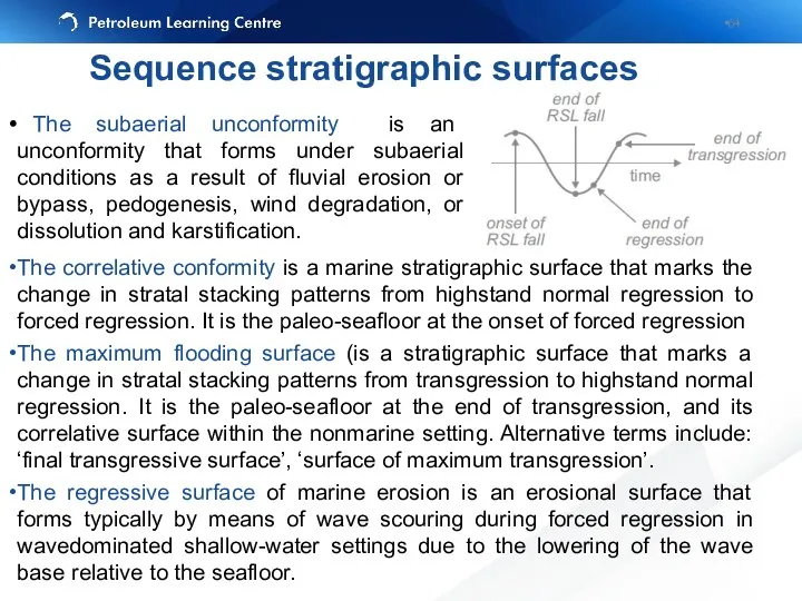
The subaerial unconformity is an unconformity that forms under subaerial
The subaerial unconformity is an unconformity that forms under subaerial
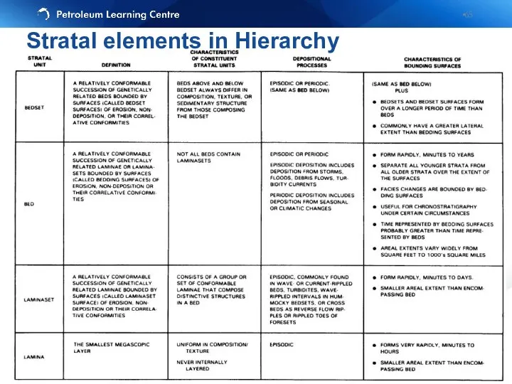
Stratal elements in Hierarchy
Stratal elements in Hierarchy
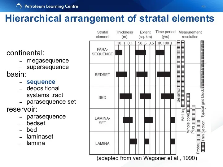
continental:
megasequence
supersequence
basin:
sequence
depositional systems tract
parasequence set
reservoir:
parasequence
bedset
bed
laminaset
lamina
(adapted from van Wagoner et al., 1990)
Hierarchical
continental:
megasequence
supersequence
basin:
sequence
depositional systems tract
parasequence set
reservoir:
parasequence
bedset
bed
laminaset
lamina
(adapted from van Wagoner et al., 1990)
Hierarchical
continental:
megasequence
supersequence
basin:
sequence
depositional systems tract
parasequence set
reservoir:
parasequence
bedset
bed
laminaset
lamina
Hierarchical arrangement of stratal elements
continental:
megasequence
supersequence
basin:
sequence
depositional systems tract
parasequence set
reservoir:
parasequence
bedset
bed
laminaset
lamina
Hierarchical arrangement of stratal elements
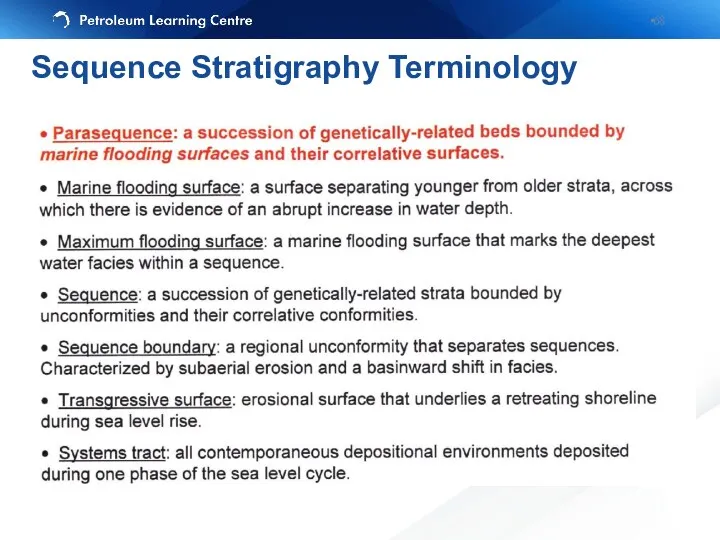
Sequence Stratigraphy Terminology
Sequence Stratigraphy Terminology
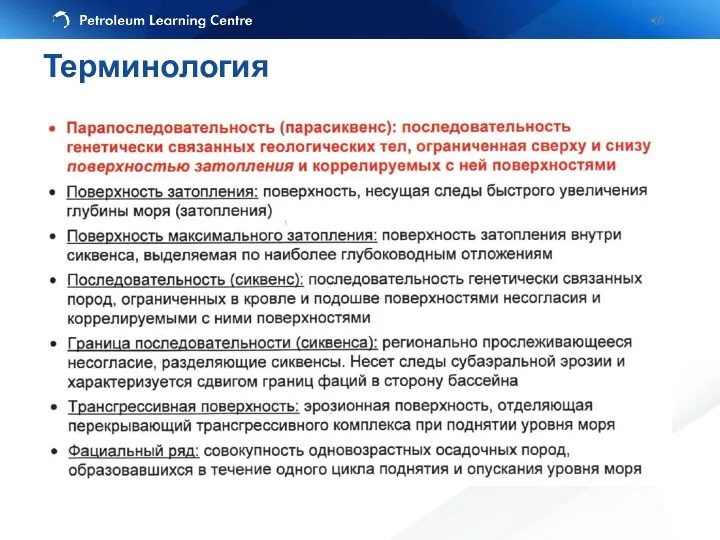
Терминология
Терминология
Accurate correlations depends on a little knowledge of the environment of
Accurate correlations depends on a little knowledge of the environment of
Shallow Marine
Cook Fm., L. Jur.
Fluvial-deltaic
Ness Fm., M.Jur.
From Livbjerg and Mjos,
Shallow Marine
Cook Fm., L. Jur.
Fluvial-deltaic
Ness Fm., M.Jur.
From Livbjerg and Mjos,
Shallow-marine deposits
Exercise 4. Different Environments
Shallow-marine deposits
Exercise 4. Different Environments
Fluvial deposits
Exercise 4. Different Environments
Fluvial deposits
Exercise 4. Different Environments
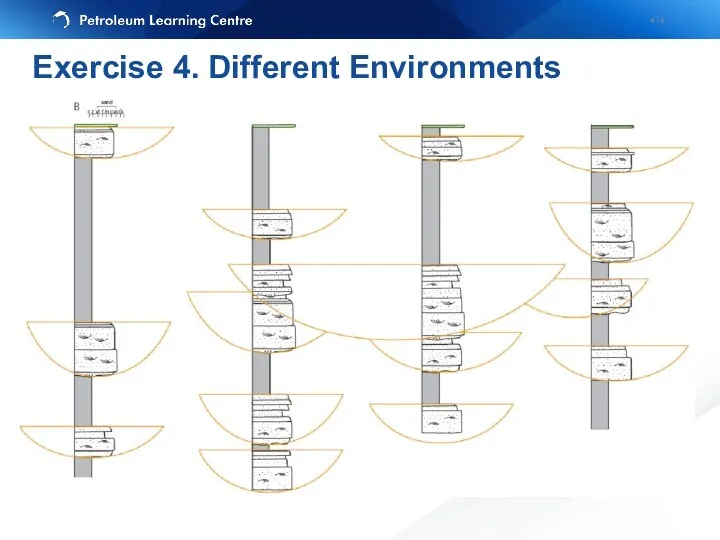
Exercise 4. Different Environments
Exercise 4. Different Environments
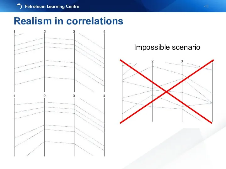
Impossible scenario
Realism in correlations
Impossible scenario
Realism in correlations
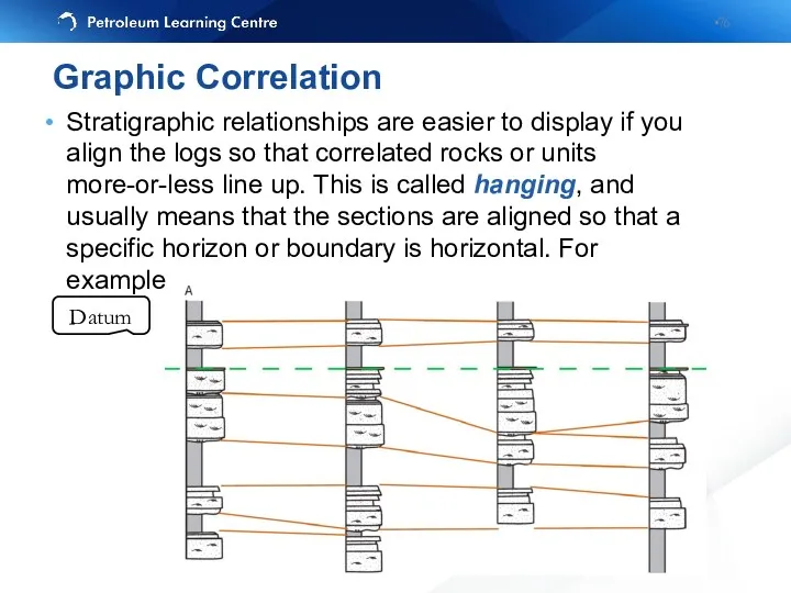
Stratigraphic relationships are easier to display if you align the logs
Stratigraphic relationships are easier to display if you align the logs
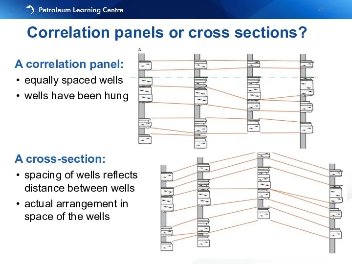
A correlation panel:
equally spaced wells
wells have been hung
A cross-section:
spacing of
A correlation panel:
equally spaced wells
wells have been hung
A cross-section:
spacing of
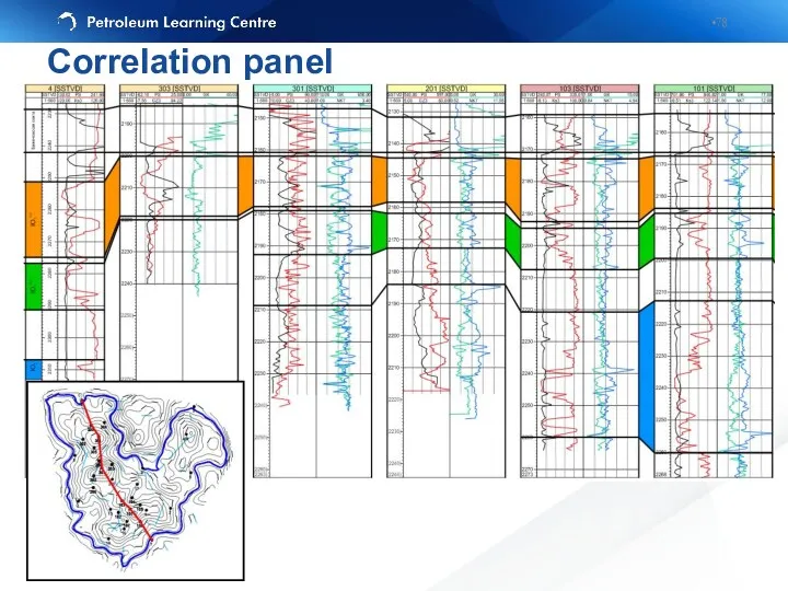
Correlation panel
Correlation panel

Cross-section
Cross-section
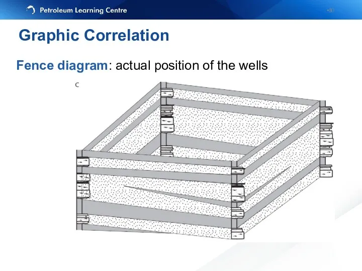
Fence diagram: actual position of the wells
Graphic Correlation
Fence diagram: actual position of the wells
Graphic Correlation
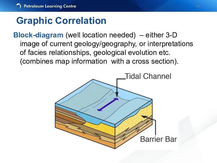
Block-diagram (well location needed) – either 3-D image of current geology/geography,
Block-diagram (well location needed) – either 3-D image of current geology/geography,
Use the log patterns to correlate, but beware of differences caused
Use the log patterns to correlate, but beware of differences caused
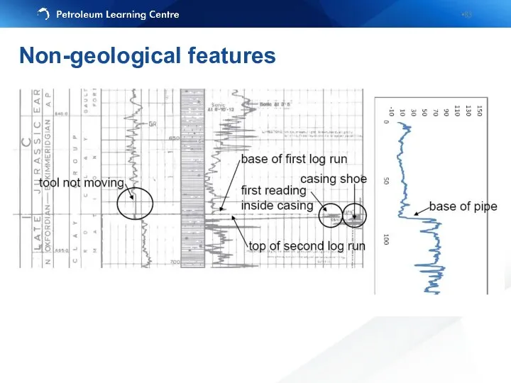
Non-geological features
Non-geological features
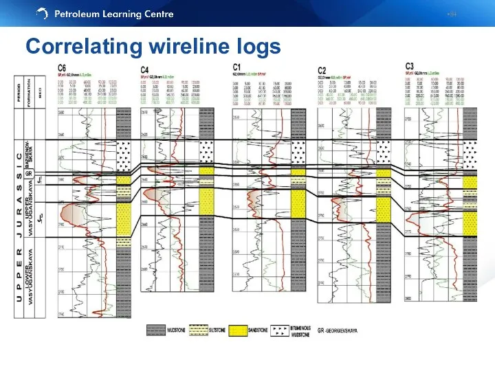
Correlating wireline logs
Correlating wireline logs
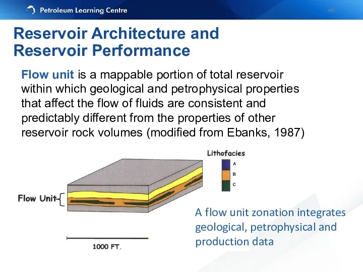
Flow unit is a mappable portion of total reservoir within which
Flow unit is a mappable portion of total reservoir within which
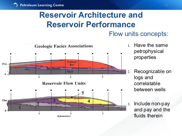
Flow units concepts:
Have the same petrophysical properties
Recognizable on logs and correlatable
Flow units concepts:
Have the same petrophysical properties
Recognizable on logs and correlatable
Reservoir Architecture and
Reservoir Performance
Reservoir Architecture and
Reservoir Performance
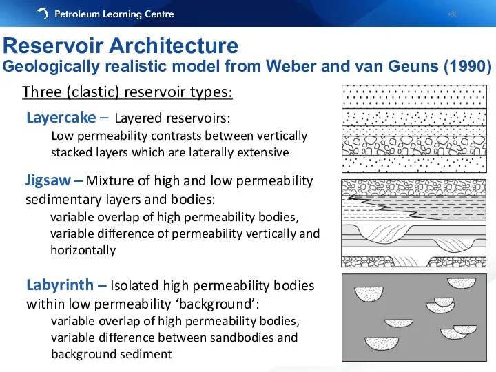
Layercake – Layered reservoirs:
Low permeability contrasts between vertically stacked layers which
Layercake – Layered reservoirs:
Low permeability contrasts between vertically stacked layers which
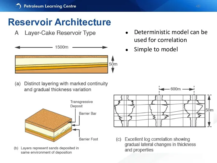
Deterministic model can be used for correlation
Simple to model
Reservoir Architecture
Deterministic model can be used for correlation
Simple to model
Reservoir Architecture
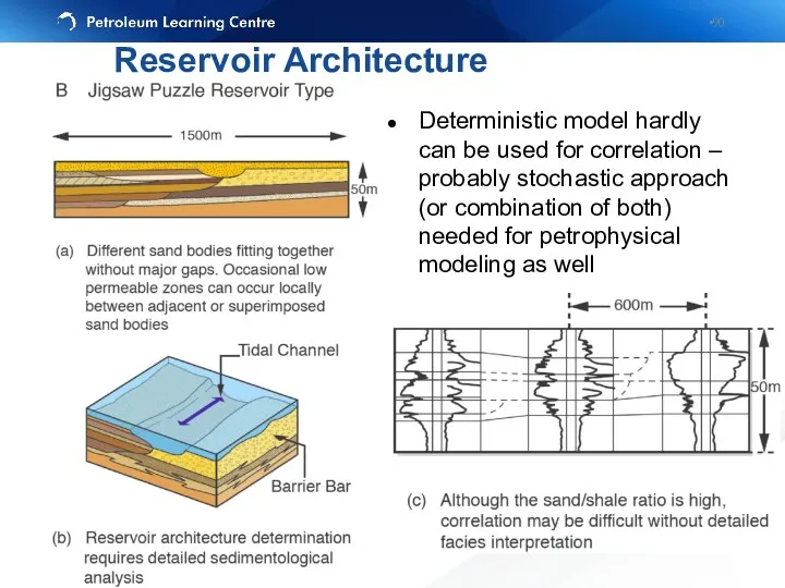
Deterministic model hardly can be used for correlation – probably stochastic
Deterministic model hardly can be used for correlation – probably stochastic

Connectivity between sand bodies is related to the proportion of sand
Connectivity between sand bodies is related to the proportion of sand
Layered architecture
(Layercake)
Mixed architecture
(Jigsaw)
Isolated architecture
(Labyrinth)
Architectural Matrix
Layered architecture
(Layercake)
Mixed architecture
(Jigsaw)
Isolated architecture
(Labyrinth)
Architectural Matrix
Layercake
Labyrinth
Jigsaw
Layercake
Jigsaw
NORTH SEA RESERVOIRS
Primary Recovery
Water Injection
Recovery as a function of geology
Layercake
Labyrinth
Jigsaw
Layercake
Jigsaw
NORTH SEA RESERVOIRS
Primary Recovery
Water Injection
Recovery as a function of geology
Sedimentary structures or stratal architecture (facies models)
Turbidites (Forties), fluvial reservoirs (Brent
Sedimentary structures or stratal architecture (facies models)
Turbidites (Forties), fluvial reservoirs (Brent
Learning objectives
Identify correlation markers
Correlate lithological units between wells using lithology
Learning objectives
Identify correlation markers
Correlate lithological units between wells using lithology
It involves:
6: Correlation and hanging
7: Faulted sections
8: Structural vs stratigraphic cross-sections
Exercise
It involves:
6: Correlation and hanging
7: Faulted sections
8: Structural vs stratigraphic cross-sections
Exercise
Дополнительные слайды
Дополнительные слайды
Эрозионное срезание (erosional truncation) — залегание вышележащих отложений выше поверхности
Эрозионное срезание (erosional truncation) — залегание вышележащих отложений выше поверхности
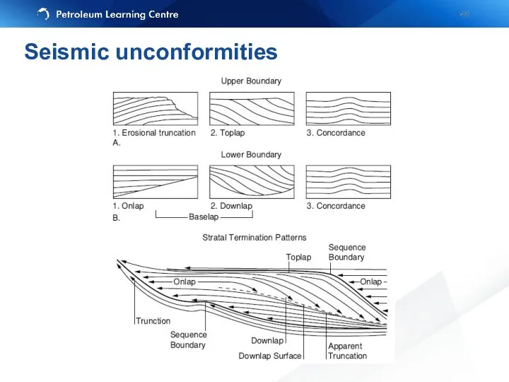
Seismic unconformities
Seismic unconformities
 History of Earth’s Climate
 Западная Сибирь
 Восточная Сибирь. 9 класс
 Швеция
 Строение Земли и методы его изучения. Литосфера
 Использование технологии проектов в изучении географии
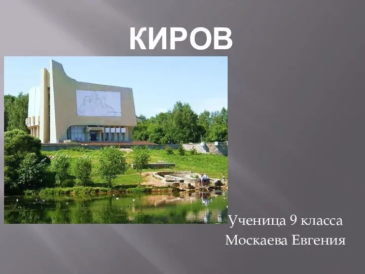 Киров – административный и культурный центр Кировской области
 Держава Грузія
 Страны Западной Европы
 Горные породы (5 класс)
 Состав и строение подземной гидросферы
 Моря, омывающие Египет
 Подземные воды, болота, ледники
 Человек и литосфера
 Крымский природный заповедник
 Топливно-энергетический комплекс России
 Логикалық есептер сайысы
 Политическая карта мира
 Открытие Южного материка Джеймсом Куком
 Республіка Польща
 Что такое карта и как её читать
 Рельеф и полезные ископаемые Африки
 Виды изображения земной поверхности. План местности. Условные знаки
 Республики входящие в состав РФ
 НАТО и СНГ. Флаги стран
 New York
 Самые необычные места в мире
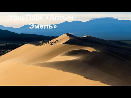 Национальный природный парк Алтын-Эмель