- Open spatial access in SDI

Содержание
- 2. 6.1. Preconditions of understanding of spatial access in SDI 1. Once spatial data of interest have
- 3. 6.2. Context and rationale of open spatial access in SDI 1. Access to spatial data from
- 4. 2. With the growth of the Internet access has become a demand driven operation. 3. Consumers
- 5. 5. Several trends can be noted in the treatment and handling of spatial data: 1) Typically
- 6. 6.3. Organisational approach to open spatial access in SDI 6.3.1. Stakeholders' categories in SDI access 1.
- 7. 3. The final category of stakeholder is the consumer or end-user: – Their use of the
- 8. 6.3.2. Development of policy/organisational environment for SDI access 1. Potential stakeholders will only become active participants
- 9. 4. Some of the issues that need to be considered in the development of the supportive
- 10. 4) Multiple levels of “buy-in”; low barrier to entry: a) The access component of the infrastructure
- 11. 5. The role the private sector as suppliers of data, services, and technology and as potential
- 12. 6.3.3. Marketing and promotion of SDI access 1. The access component of an infrastructure must develop
- 13. 3. Potential benefits to suppliers include: 1) Economies of data collection, closest to the source; 2)
- 14. 6.4. Implementation approach to open spatial access in SDI: definitions and overview 6.4.1. Data sets in
- 15. 6.4.2. Data stores in SDI access 1. Data stores are used to manage data sets. 2.
- 16. 6.4.3 Spatial data warehouse in SDI access 1. A spatial data warehouse provides storage, management and
- 17. 3. Examples of commercial data warehousing and service solutions for geospatial data include: a) Cubestore from
- 18. 6.4.4. Data access service in SDI 1. Implementations of data access services include the following services:
- 19. 4) Online data service (e.g. request/response access protocol to data warehouse) supporting online operations such as:
- 20. Fig.6.1 – OGC Portrayal model 20
- 21. 6.4.5. SDI data access clients Online implementations of data access clients include: 1) 'Thin client', which
- 22. 6.4.5. SDI data access clients: 4) Traditional GIS type client, which need access to previously downloaded
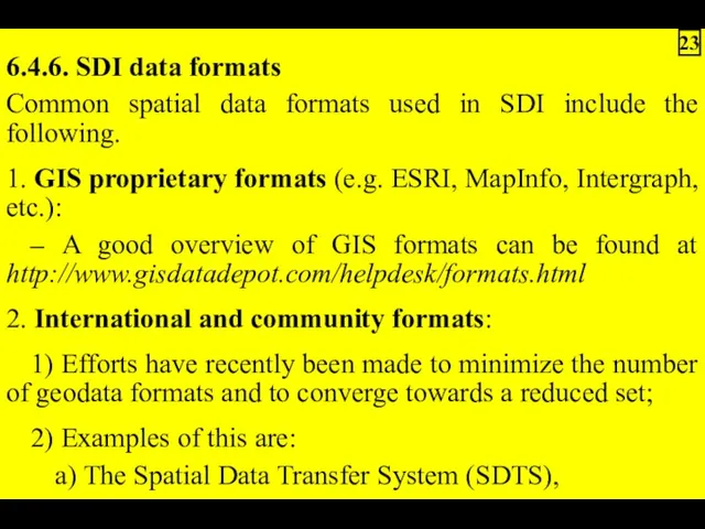
- 23. 6.4.6. SDI data formats Common spatial data formats used in SDI include the following. 1. GIS
- 24. 3) There are also exchange formats that allow the use of data outside of closed environments:
- 25. 6) Currently, most GIS and related access systems support format translation. Examples of commercial support for
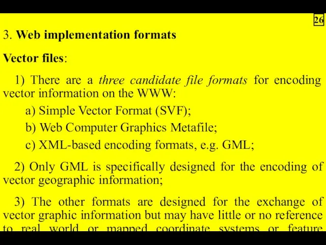
- 26. 3. Web implementation formats Vector files: 1) There are a three candidate file formats for encoding
- 27. Raster files: 1) Web/internet delivery of GIS raster formats such as ADRG, BIL and DEM is
- 28. 6.5. SDI data access's relationship to other SDI services 1. Figure 6.2 illustrates the relationship role
- 29. Fig.6.2 – Spatial resource discovery, evaluation and access paradigm 29
- 30. 5. Future capability for chaining of distributed geoprocessing services is also expected. 6. A system context
- 31. Fig.6.3 – System context for spatial data access services 31
- 32. 6.6. SDI data access standards In general, standards related to spatial data access are still in
- 33. 6.6.1. ISO/TC211 data access standards 1. The primary mandate of ISO/TC211 is international standardization in the
- 34. 6.6.2. Open GIS Consortium (OGC) data access specification 1. The Open GIS Consortium has achieved consensus
- 35. Fig.6.4 – UML Model of the OGC Feature Model 35
- 36. 4. Web Feature Service (WFS): 1) A service that can describe data manipulation operations on OGC
- 37. 5. The OGC Web Coverage Service (WCS) Specification was published in 2003. 6. It extends the
- 38. 3) Coverage is a feature that acts as a function to return values from its range
- 39. 8. The OGC Web Coverage Service (WCS) Specification have also been released to support feature access
- 40. 6.6.3. Web and Internet related data access specifications 1. The World Wide Web consortium or W3C
- 41. 6.7. Best practice application of SDI open data access 1. One common problem with online access
- 42. 2. One example of services to support the third paradigm is GeoGratis (http://geogratis.cgdi.gc.ca/) that provides common
- 43. 6.8. Evolution of data access and related spatial data services towards SDI 1. The matrix below
- 45. Скачать презентацию
6.1. Preconditions of understanding of spatial access in SDI
1. Once spatial
1. Once spatial
6.2. Context and rationale of open spatial access in SDI
1. Access
1. Access
2. With the growth of the Internet access has become a
5. Several trends can be noted in the treatment and handling
6.3. Organisational approach to open spatial access in SDI
6.3.1. Stakeholders' categories
6.3.1. Stakeholders' categories
3. The final category of stakeholder is the consumer or end-user:
–
–
6.3.2. Development of policy/organisational environment for SDI access
1. Potential stakeholders will
1. Potential stakeholders will
4. Some of the issues that need to be considered in
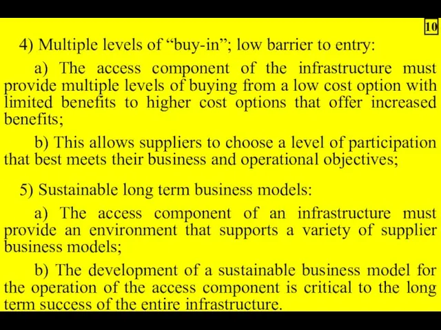
4) Multiple levels of “buy-in”; low barrier to entry:
a) The access
a) The access

5. The role the private sector as suppliers of data, services,
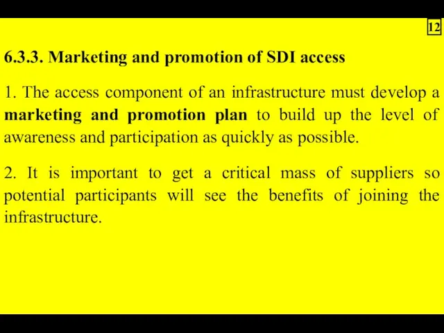
6.3.3. Marketing and promotion of SDI access
1. The access component of
1. The access component of
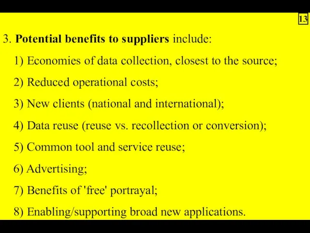
3. Potential benefits to suppliers include:
1) Economies of data collection, closest
1) Economies of data collection, closest
6.4. Implementation approach to open spatial access in SDI: definitions and
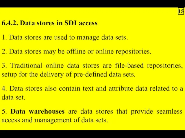
6.4.2. Data stores in SDI access
1. Data stores are used to
1. Data stores are used to
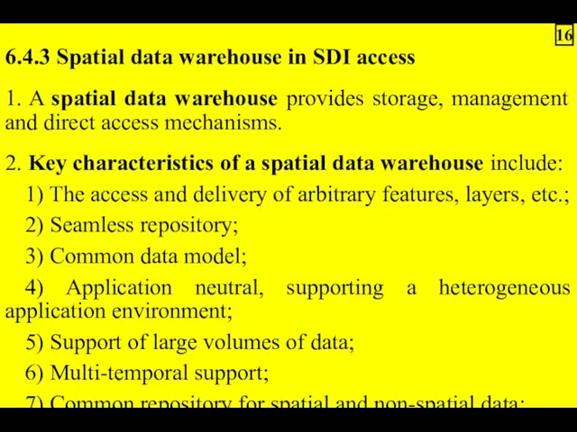
6.4.3 Spatial data warehouse in SDI access
1. A spatial data warehouse
1. A spatial data warehouse
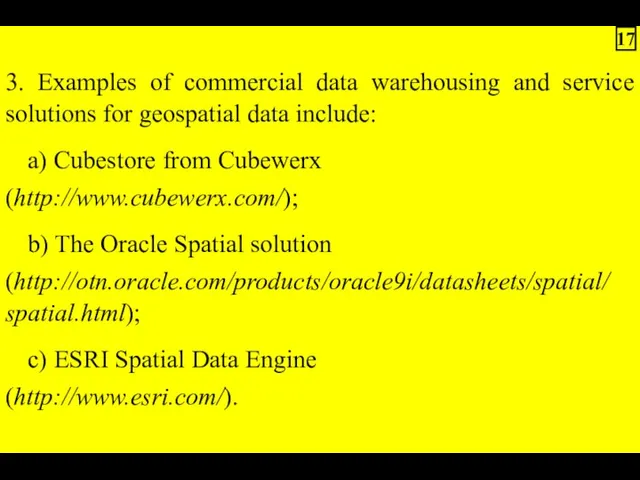
3. Examples of commercial data warehousing and service solutions for geospatial
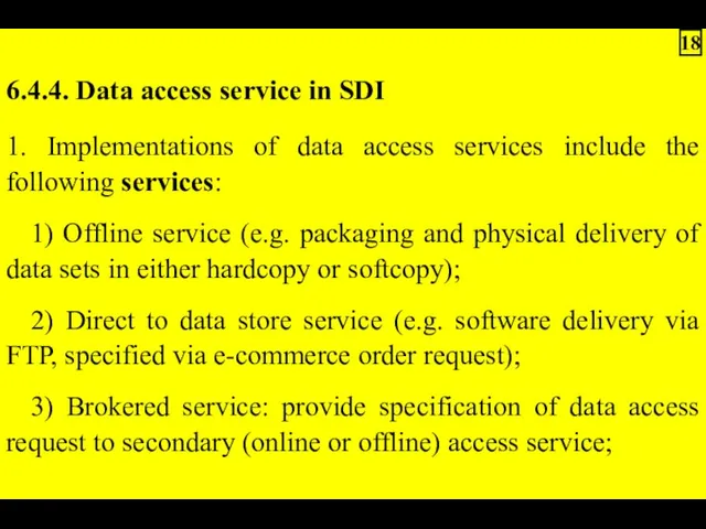
6.4.4. Data access service in SDI
1. Implementations of data access services
1. Implementations of data access services
4) Online data service (e.g. request/response access protocol to data warehouse)
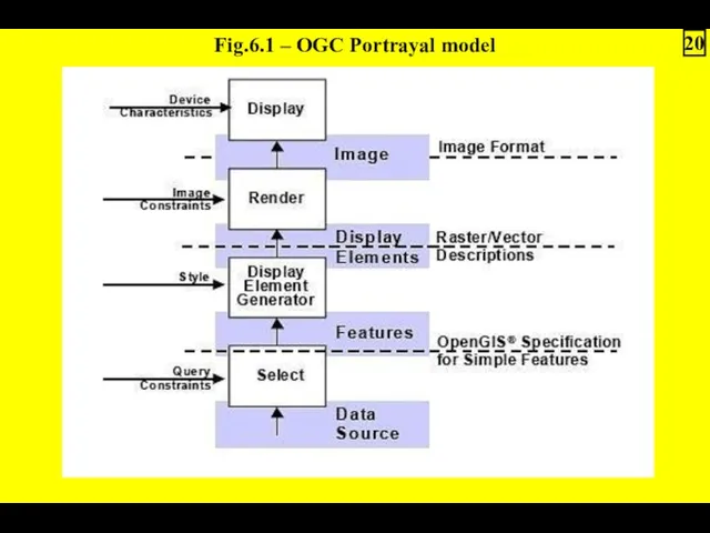
Fig.6.1 – OGC Portrayal model
20
Fig.6.1 – OGC Portrayal model
20
6.4.5. SDI data access clients
Online implementations of data access clients include:
1)
Online implementations of data access clients include:
1)
6.4.5. SDI data access clients:
4) Traditional GIS type client, which need
4) Traditional GIS type client, which need
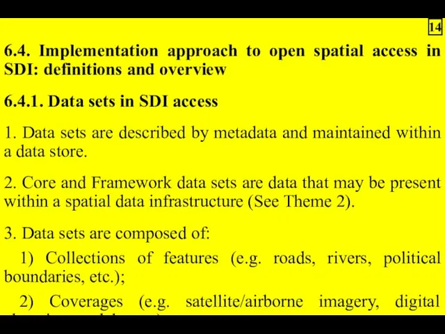
6.4.6. SDI data formats
Common spatial data formats used in SDI include
Common spatial data formats used in SDI include
3) There are also exchange formats that allow the use of
6) Currently, most GIS and related access systems support format translation.
3. Web implementation formats
Vector files:
1) There are a three candidate
Vector files:
1) There are a three candidate
Raster files:
1) Web/internet delivery of GIS raster formats such as ADRG,
1) Web/internet delivery of GIS raster formats such as ADRG,
6.5. SDI data access's relationship to other SDI services
1. Figure 6.2
1. Figure 6.2
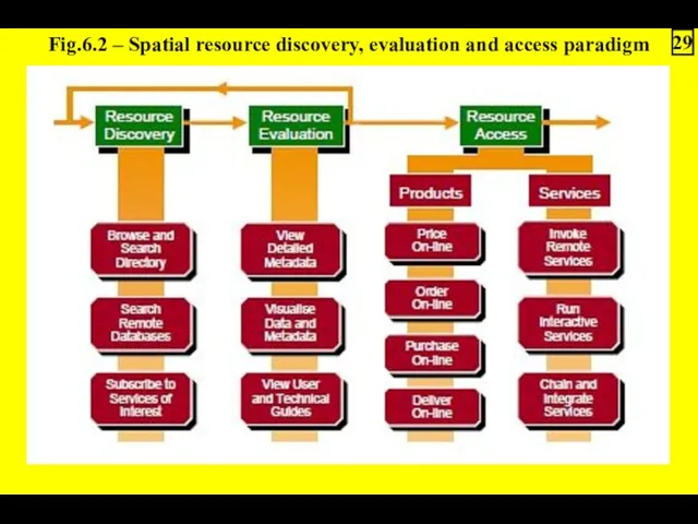
Fig.6.2 – Spatial resource discovery, evaluation and access paradigm
29
Fig.6.2 – Spatial resource discovery, evaluation and access paradigm
29
5. Future capability for chaining of distributed geoprocessing services is also
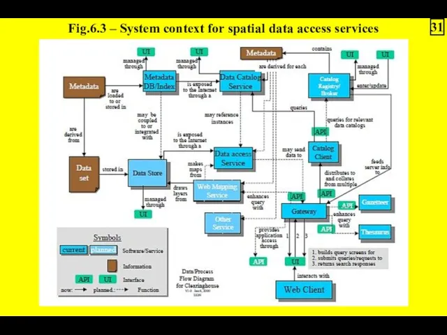
Fig.6.3 – System context for spatial data access services
31
Fig.6.3 – System context for spatial data access services
31
6.6. SDI data access standards
In general, standards related to spatial data
In general, standards related to spatial data
6.6.1. ISO/TC211 data access standards
1. The primary mandate of ISO/TC211 is
1. The primary mandate of ISO/TC211 is
6.6.2. Open GIS Consortium (OGC) data access specification
1. The Open GIS
1. The Open GIS
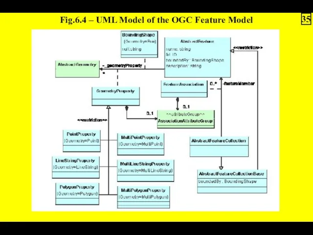
Fig.6.4 – UML Model of the OGC Feature Model
35
Fig.6.4 – UML Model of the OGC Feature Model
35
4. Web Feature Service (WFS):
1) A service that can describe data
1) A service that can describe data
5. The OGC Web Coverage Service (WCS) Specification was published in
3) Coverage is a feature that acts as a function to
8. The OGC Web Coverage Service (WCS) Specification have also been
6.6.3. Web and Internet related data access specifications
1. The World Wide
1. The World Wide
6.7. Best practice application of SDI open data access
1. One common
1. One common
 Презентация к уроку Циклы на паскале
 Данные. Виды и типы данных
 Понятие мультимедиа
 Презентация к занятию по внеурочной деятельности: Возникновение мультипликации
 Библиографическое описание для составления списка литературы
 Фреймворки. Популярные фреймворки для веб-разработки
 Перечень опасных событий. Модели угроз нарушителя и модель защиты от компьютерных атак. (Лекция 3)
 Лекция 3. Виды компьютерной графики
 Тестирование ПО. Виды тестирования. Лекция 4
 Операции, линейный алгоритм. (Семинар 1-3)
 Программное обеспечение
 Внедрение Битрикс24 в сфере услуг
 Информация в живой и неживой природе
 Дискретные и непрерывные модели
 Компьютер и его части. 2 класс
 Основы программирования на языке Паскаль
 А что такое ОС?
 Основы программирования на языке высокого уровня. Модуль 1
 Переход от REST API к GraphQL на примере реальных проектов
 Урок по теме Действия с фрагментом рисунка в графическом редакторе Paint
 Доменная система имён. Протоколы передачи данных
 Курсоры. Типы курсоров в Т-SQL
 Информационная культура
 Развитие автомобильных телеканалов в 2019 г
 Язык программирования Python
 Курсовий проект. Побудова графіку функції за наданим користувачем рядком, що містить припустимий опис функції
 Технологии аналитики и визуализации больших данных (лекция № 7)
 Социальные сети: почему люди предпочитают живому общению виртуальное?